Edinburg, Virginia facts for kids
Quick facts for kids
Edinburg, Virginia
|
|
|---|---|

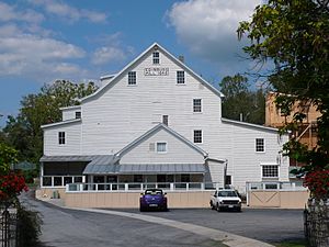
The Mill in Edinburg, Virginia (1848).
|
|

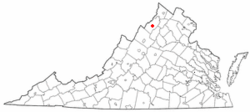
Location in Virginia
|
|
| Country | United States |
| State | Virginia |
| County | Shenandoah |
| Founded | 1852 |
| Area | |
| • Total | 0.76 sq mi (1.96 km2) |
| • Land | 0.74 sq mi (1.92 km2) |
| • Water | 0.02 sq mi (0.05 km2) |
| Elevation | 807 ft (246 m) |
| Population
(2010)
|
|
| • Total | 1,041 |
| • Estimate
(2019)
|
1,070 |
| • Density | 1,443.99/sq mi (557.80/km2) |
| Time zone | UTC−5 (Eastern (EST)) |
| • Summer (DST) | UTC−4 (EDT) |
| ZIP code |
22824
|
| Area code(s) | 540 |
| FIPS code | 51-25008 |
| GNIS feature ID | 1494215 |
| Website | http://www.townofedinburg.com |
Edinburg is a small town in Shenandoah County, Virginia, in the United States. In 2010, about 1,041 people lived there. It is a quiet place with a rich history in the beautiful Shenandoah Valley.
Contents
History of Edinburg
Edinburg has a long and interesting history. Before it officially became a town in 1852, it was known by other names like Shryock and Stony Creek.
Historic Buildings and Farms
Several important places in Edinburg are listed on the National Register of Historic Places. This is a special list of buildings, sites, and objects that are important to the history of the United States. These places include:
- Bowman-Zirkle Farm
- Campbell Farm
- Clem-Kagey Farm
- Edinburg Historic District (a whole area with historic buildings)
- Edinburg Mill
- Dr. Christian Hockman House
- Lantz Mill
- John Miley Maphis House
These sites help us remember the past and how people lived in Edinburg many years ago.
Geography of Edinburg
Edinburg is located in the Shenandoah Valley of Virginia. You can find it at coordinates 38°49′21″N 78°33′55″W / 38.82250°N 78.56528°W.
Size of the Town
The United States Census Bureau says that Edinburg covers about 0.7 square miles (1.9 square kilometers). All of this area is land.
Transportation in Edinburg
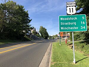
Getting around Edinburg is easy. The main road that goes through the town is U.S. Route 11. It is also known as Main Street.
Connecting Roads
Virginia State Route 185 helps connect U.S. Route 11 to Interstate 81. Interstate 81 is a big highway that runs north and south just west of Edinburg.
Population of Edinburg
The number of people living in Edinburg has changed over the years.
| Historical population | |||
|---|---|---|---|
| Census | Pop. | %± | |
| 1860 | 514 | — | |
| 1870 | 452 | −12.1% | |
| 1880 | 478 | 5.8% | |
| 1890 | 512 | 7.1% | |
| 1900 | 512 | 0.0% | |
| 1910 | 574 | 12.1% | |
| 1920 | 568 | −1.0% | |
| 1930 | 498 | −12.3% | |
| 1940 | 565 | 13.5% | |
| 1950 | 533 | −5.7% | |
| 1960 | 517 | −3.0% | |
| 1970 | 766 | 48.2% | |
| 1980 | 752 | −1.8% | |
| 1990 | 860 | 14.4% | |
| 2000 | 813 | −5.5% | |
| 2010 | 1,041 | 28.0% | |
| 2019 (est.) | 1,070 | 2.8% | |
| U.S. Decennial Census | |||
People and Households
According to the census from 2000, there were 813 people living in Edinburg. These people lived in 385 households, and 220 of these were families.
- About 20.5% of households had children under 18 living with them.
- Many households (42.6%) were married couples living together.
- The average household had about 2.09 people.
- The average family had about 2.71 people.
Age of Residents
In 2000, the median age in Edinburg was 41 years old. This means half the people were younger than 41 and half were older.
- About 18.1% of the population was under 18 years old.
- About 21.4% of the population was 65 years or older.
See also
 In Spanish: Edinburg (Virginia) para niños
 | Aaron Henry |
 | T. R. M. Howard |
 | Jesse Jackson |


