Edinburg Township, Ohio facts for kids
Quick facts for kids
Edinburg Township
|
|
|---|---|

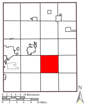
Location within Portage County
|
|
| Country | United States |
| State | Ohio |
| County | Portage |
| Area | |
| • Total | 24.5 sq mi (63.4 km2) |
| • Land | 24.2 sq mi (62.6 km2) |
| • Water | 0.3 sq mi (0.7 km2) |
| Elevation | 1,181 ft (360 m) |
| Population
(2020)
|
|
| • Total | 2,351 |
| • Density | 97.1/sq mi (37.6/km2) |
| Time zone | UTC-5 (Eastern (EST)) |
| • Summer (DST) | UTC-4 (EDT) |
| ZIP code |
44272 and 44266
|
| Area code(s) | 330 |
| FIPS code | 39-24584 |
| GNIS feature ID | 1086826 |

Edinburg Township is one of eighteen townships in Portage County, Ohio, United States. A township is like a small local government area. In 2020, a count of the population showed that 2,351 people lived in the township.
Contents
Where is Edinburg Township?
Edinburg Township is located in the southeastern part of Portage County. It shares its borders with several other townships:
- Charlestown Township to the north
- Paris Township at the northeast corner
- Palmyra Township to the east
- Deerfield Township at the southeast corner
- Atwater Township to the south
- Randolph Township at the southwest corner
- Rootstown Township to the west
- Ravenna Township at the northwest corner
There are no cities or towns located within Edinburg Township itself.
Size of the Township
Edinburg Township was created from an area known as the Connecticut Western Reserve. This was a piece of land in Ohio that Connecticut once claimed. The township covers an area of about 24 sq mi (62 km2).
The Story of Edinburg Township
The first people settled in Edinburg in 1815. The township was officially set up in 1819.
How Edinburg Got Its Name
The township is named after Lewis Eddy, who was one of the first settlers in the area. It was first called "Eddysburg." Edinburg Township is the only township with this name in the entire state of Ohio.
Early Services
A post office was opened in Edinburg in 1822. This allowed people to send and receive mail. The post office served the community for many years, until it closed in 1903.
See also
 In Spanish: Municipio de Edinburg para niños
 | Sharif Bey |
 | Hale Woodruff |
 | Richmond Barthé |
 | Purvis Young |


