
Ehrenberg, Arizona facts for kids
Quick facts for kids
Ehrenberg, Arizona
|
|
|---|---|
.jpg)
Welcome to Ehrenberg, Arizona (Ghost Town)
|
|

Location in La Paz County and the state of Arizona
|
|
| Country | United States |
| State | Arizona |
| County | La Paz |
| Area | |
| • Total | 12.13 sq mi (31.43 km2) |
| • Land | 11.92 sq mi (30.88 km2) |
| • Water | 0.21 sq mi (0.54 km2) |
| Elevation | 377 ft (115 m) |
| Population
(2020)
|
|
| • Total | 763 |
| • Density | 63.99/sq mi (24.71/km2) |
| Time zone | UTC-7 (MST (no DST)) |
| ZIP code |
85334
|
| Area code(s) | 928 |
| FIPS code | 04-21800 |
| GNIS feature ID | 2408050 |
Ehrenberg is a small community in La Paz County, Arizona, United States. It's called a "census-designated place" (CDP) because it's a specific area the government tracks for population, but it doesn't have its own city government. In 2020, about 763 people lived there.
The town is named after its founder, Herman Ehrenberg. It sits right on the Colorado River, which is the border between Arizona and California. Ehrenberg is also very close to Interstate 10, a major highway.
Contents
History of Ehrenberg
How Ehrenberg Started
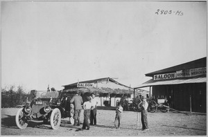
Ehrenberg began in 1863. A German engineer named Herman Ehrenberg was hired to find a good spot for a new town. This new town was about 6 miles from another place called La Paz, Arizona.
The town was first called Mineral City. It started growing in 1866. This happened because a new "landing" was built there. A landing is a place where boats can stop to load and unload goods. Steamboat captains from the George A. Johnson Company used this new landing.
Growth and Renaming
Mineral City quickly became popular. Many miners and business people moved there from La Paz. By September 1869, the town was big enough to get its own post office. In the same year, its name was changed to "Ehrenberg."
For several years, Ehrenberg kept growing. It became bigger than La Paz. By 1875, about 500 people lived in Ehrenberg. Many shop owners from La Paz moved their businesses to Ehrenberg.
Decline of the Town
Around the early 1900s, things changed. Railroads became the main way to move goods. This meant that river travel, which Ehrenberg depended on, was used less. Because of this, the town's population started to shrink. Ehrenberg lost its post office on December 31, 1913.
Later, in the 1950s, many of the old buildings were taken down. This was to make room for a place where people could park their trailers.
Geography and Climate
Where is Ehrenberg?
Ehrenberg is in the western part of La Paz County. It's right on the Colorado River, which forms the border between Arizona and California. The community is located along Interstate 10. This highway goes east about 145 miles to Phoenix. It goes west about 100 miles to Indio, California.
The Ehrenberg area covers about 12.1 square miles. Most of this area is land, but about 0.2 square miles is water.
What is the Climate Like?
Ehrenberg has a desert climate. This means it gets a lot of sunshine all year. The air is usually stable and there is high pressure. On climate maps, this type of weather is called "Bwh."
| Climate data for Ehrenburg, Arizona, 1991–2020 normals, extremes 1977–2018 | |||||||||||||
|---|---|---|---|---|---|---|---|---|---|---|---|---|---|
| Month | Jan | Feb | Mar | Apr | May | Jun | Jul | Aug | Sep | Oct | Nov | Dec | Year |
| Record high °F (°C) | 87 (31) |
92 (33) |
98 (37) |
107 (42) |
115 (46) |
123 (51) |
123 (51) |
119 (48) |
116 (47) |
110 (43) |
96 (36) |
84 (29) |
123 (51) |
| Mean maximum °F (°C) | 77.1 (25.1) |
83.1 (28.4) |
91.0 (32.8) |
99.9 (37.7) |
106.8 (41.6) |
113.1 (45.1) |
115.7 (46.5) |
114.3 (45.7) |
110.7 (43.7) |
100.6 (38.1) |
87.5 (30.8) |
75.5 (24.2) |
116.5 (46.9) |
| Mean daily maximum °F (°C) | 67.8 (19.9) |
72.3 (22.4) |
78.8 (26.0) |
86.2 (30.1) |
94.7 (34.8) |
104.5 (40.3) |
107.9 (42.2) |
107.4 (41.9) |
101.7 (38.7) |
89.8 (32.1) |
76.7 (24.8) |
65.8 (18.8) |
87.8 (31.0) |
| Daily mean °F (°C) | 55.3 (12.9) |
58.7 (14.8) |
64.7 (18.2) |
71.2 (21.8) |
79.9 (26.6) |
89.1 (31.7) |
94.3 (34.6) |
94.1 (34.5) |
87.9 (31.1) |
75.6 (24.2) |
62.8 (17.1) |
53.2 (11.8) |
73.9 (23.3) |
| Mean daily minimum °F (°C) | 42.7 (5.9) |
45.2 (7.3) |
50.6 (10.3) |
56.2 (13.4) |
65.2 (18.4) |
73.7 (23.2) |
80.6 (27.0) |
80.8 (27.1) |
74.1 (23.4) |
61.4 (16.3) |
48.8 (9.3) |
40.6 (4.8) |
60.0 (15.5) |
| Mean minimum °F (°C) | 34.9 (1.6) |
37.0 (2.8) |
41.6 (5.3) |
48.4 (9.1) |
55.0 (12.8) |
63.6 (17.6) |
74.0 (23.3) |
72.4 (22.4) |
64.3 (17.9) |
51.6 (10.9) |
39.1 (3.9) |
32.3 (0.2) |
31.1 (−0.5) |
| Record low °F (°C) | 28 (−2) |
26 (−3) |
35 (2) |
37 (3) |
40 (4) |
51 (11) |
62 (17) |
63 (17) |
57 (14) |
42 (6) |
31 (−1) |
25 (−4) |
25 (−4) |
| Average precipitation inches (mm) | 0.70 (18) |
0.65 (17) |
0.47 (12) |
0.11 (2.8) |
0.06 (1.5) |
0.00 (0.00) |
0.23 (5.8) |
0.33 (8.4) |
0.47 (12) |
0.30 (7.6) |
0.18 (4.6) |
0.55 (14) |
4.05 (103.7) |
| Average precipitation days (≥ 0.01 in) | 2.4 | 2.4 | 2.0 | 0.6 | 0.3 | 0.0 | 0.9 | 1.1 | 1.9 | 1.1 | 0.8 | 1.7 | 15.2 |
| Source 1: NOAA | |||||||||||||
| Source 2: XMACIS2 (mean maxima/minima 1981–2010) | |||||||||||||
People of Ehrenberg
| Historical population | |||
|---|---|---|---|
| Census | Pop. | %± | |
| 2020 | 763 | — | |
| U.S. Decennial Census | |||
In 2000, there were 1,357 people living in Ehrenberg. They lived in 545 households, and 348 of these were families. The population density was about 113.7 people per square mile. There were 824 homes available.
Most people in Ehrenberg were White (82.8%). About 10.5% were from other races, and 3.8% were from two or more races. About 30.1% of the people were Hispanic or Latino.
About 31.9% of households had children under 18. About 45.7% were married couples. Around 27.7% of households were individuals living alone. About 9.5% of people living alone were 65 or older. The average household had 2.5 people.
The population was spread out by age. About 28% were under 18. About 12.7% were 65 or older. The average age was 37 years old. For every 100 females, there were about 110 males.
The average income for a household was $27,000. For families, it was $28,000. The income per person was $14,372. About 22.7% of the people lived below the poverty line. This included 25.7% of those under 18.
Images for kids
Here are some of the old buildings and important places still standing in Ehrenberg:
-
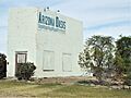
General Store
-
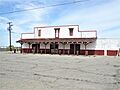
Old Meat Market
-
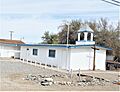
Old Ehrenberg Community Church
-
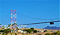
The Blythe-Ehrenberg-Pipeline suspension bridge
-
Different view of the Blythe-Ehrenberg-Pipeline suspension bridge
-
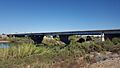
Interstate 10/US Route 95 The Ehrenberg-Blythe Colorado River Bridge as seen from Ehrenberg
-
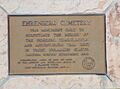
Ehrenberg Pioneer Cemetery Marker
-
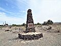
Ehrenberg Pioneer Cemetery Monument
-
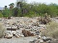
Unmarked graves in the Ehrenberg Pioneer Cemetery
-
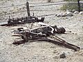
Remains of an old wagon in the Ehrenberg Pioneer Cemetery


See also
 In Spanish: Ehrenberg (Arizona) para niños
