
Eimeo, Queensland facts for kids
Quick facts for kids EimeoMackay, Queensland |
|||||||||||||||
|---|---|---|---|---|---|---|---|---|---|---|---|---|---|---|---|
.jpg)
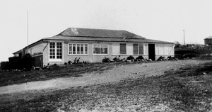
Eimeo Beach, 1976.jpg
|
|||||||||||||||

Eimeo
Location in Queensland
|
|||||||||||||||
| Population | 3,285 (2021 census) | ||||||||||||||
| • Density | 966/km2 (2,500/sq mi) | ||||||||||||||
| Postcode(s) | 4740 | ||||||||||||||
| Area | 3.4 km2 (1.3 sq mi) | ||||||||||||||
| Time zone | AEST (UTC+10:00) | ||||||||||||||
| Location |
|
||||||||||||||
| LGA(s) | Mackay Region | ||||||||||||||
| State electorate(s) | Whitsunday | ||||||||||||||
| Federal Division(s) | Dawson | ||||||||||||||
|
|||||||||||||||
Eimeo is a lovely coastal town and suburb in Queensland, Australia. It's part of the Mackay Region. In 2021, about 3,285 people lived there.
Contents
Exploring Eimeo's Geography
Eimeo is a coastal town with a special piece of land called a headland. This headland sticks out north into the beautiful Coral Sea. The very tip of the headland is rocky. However, both the eastern and western sides of the headland have sandy beaches.
Sunset Bay is located to the west of the headland. It stretches into the nearby suburb of Bucasia. Eimeo Creek flows into Sunset Bay. This creek also helps to mark the boundary between Eimeo and Bucasia.
Eimeo's Interesting History

The name Eimeo comes from a special name used by an early settler, Jeremiah Downs Armitage. He arrived in the 1870s and named his land after his birthplace, Moorea in Tahiti. Moorea was also known as Eimeo. Jeremiah's father, Elijah Armitage, was a missionary in the South Seas.
Jeremiah Armitage did many different jobs. He cut timber, grew fruit, and ran a boarding house or hotel. His most lasting gift to the area is a beautiful avenue of mango trees. He likely planted these trees in the 1880s. They marked the path from the main Mackay road to his boarding house. These old trees are still there today. They are even listed on the Queensland Heritage Register. Palm Avenue is another famous and important part of the suburb.
Schools and Fun in Eimeo's Past
Eimeo Road State School first opened its doors on 5 February 1934. It is the biggest primary school in the Whitsunday, Mackay, and Isaac Regions. However, it is no longer located within Eimeo itself. It is now in the neighbouring suburb of Rural View.

In the 1930s, a fun roller skating rink was built right next to the hotel. The Eimeo Post Office opened on 24 January 1949 but closed in 1972. The current Eimeo Pacific Hotel was built in 1954. It stands on the same spot where Armitage's original boarding house once was.
Eimeo's Population Over Time
The number of people living in Eimeo has changed a little over the years.
- In 2011, about 3,309 people lived in Eimeo.
- In 2016, the population was around 3,230 people.
- By 2021, the number of residents was 3,285 people.
Special Places in Eimeo

Eimeo has some important places that are protected for their history. These are called heritage-listed sites.
- Mango Avenue: This beautiful avenue of mango trees is located between Whittles Lane and Heidke Street. It's a very special part of Eimeo's history.
Learning in Eimeo
There are no schools directly within Eimeo itself. However, students can easily go to schools in the nearby suburb of Rural View. The closest primary school is Eimeo Road State School. For older students, Mackay Northern Beaches State High School is also in Rural View.
Fun Things to Do in Eimeo

Eimeo offers several great spots for fun and relaxation.
- Eimeo Pacific Hotel: This hotel is located right on the northern tip of the headland at 1 Mango Avenue. It's a great spot to visit.
- Eimeo Surf Lifesaving Club: If you love the beach, this club is right on the sand. It's just below and to the east of the hotel. They help keep people safe in the water.

- Boat Ramp: There's a boat ramp at Sunset Boulevard. You can use it to launch boats into Eimeo Creek. The Mackay Regional Council manages this ramp.
Parks for Play and Relaxation
Eimeo has many parks where you can play or relax. Here are some of them:
- Barber Drive Park
- Barber Park
- Botha Street Park
- Busuttin Drive Park
- Eulbertie Ave Park
- Hermitage Drive Park
- Langer Drive Park
- Mango Ave Park
- Mclaughlin Drive Park
- Shann Street Park
