
El Calafate facts for kids
Quick facts for kids
El Calafate
|
||
|---|---|---|
.jpg) |
||
|
||

El Calafate
Location in Santa Cruz Province

El Calafate
Location in Argentina
|
||
| Country | Argentina | |
| Province | ||
| Department | Lago Argentino | |
| Population
(2022 census)
|
||
| • Total | 25,172 | |
| Demonym(s) | calafateño/a | |
| Time zone | UTC-3 (ART) | |
| CPA base |
Z9405
|
|
| Dialing code | +54 2965 | |
| Climate | BSk | |

El Calafate, often just called Calafate, is a town in Argentina. It's located in the Santa Cruz province, which is part of Patagonia. The town sits on the southern edge of Lago Argentino.
The name "Calafate" comes from a small bush that grows a lot in this area. This bush has yellow flowers and dark-blue berries. The Spanish word calafate means 'caulk', which is a material used to seal things.
El Calafate is a very popular place for tourists. It's the main starting point for people who want to visit amazing places like Los Glaciares National Park, the famous Perito Moreno Glacier, and tall mountains like Cerro Chaltén and Cerro Torre.
Contents
History of El Calafate
The story of modern El Calafate began in the early 1900s. Back then, it was mostly a resting spot for people who traded wool.
The Argentine government officially founded the town in 1927. They wanted to encourage more people to live there. The real growth started when Perito Moreno National Park was created nearby in 1937. This led to better roads and more people moving to the area. Over the years, as more tourists, especially those interested in nature, visited, the town grew a lot. Its population increased by tens of thousands.
Getting Around El Calafate
El Calafate is connected by paved roads to other towns. For example, it's 220 kilometers (about 137 miles) from El Chaltén. It's also 315 kilometers (about 196 miles) from Río Gallegos.
The town has its own airport, El Calafate International Airport. It's located about 20 kilometers (12 miles) east of the city. This makes it easy for visitors to fly in.
-
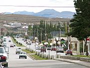
Avenida del Libertador, the town's main street
-
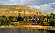
Residential section of the city
-
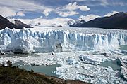
El Calafate is located near Los Glaciares National Park
-
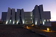
Glacier Research Center


Population Growth
In 2001, about 6,410 people lived permanently in El Calafate. This was a big jump from 3,101 people in 1991.
Because tourism grew so much, the population kept increasing. By 2010, there were 18,896 residents. In 2020, it reached 28,766. The most recent count in 2022 showed the population at 25,172.
Wildlife in the Area
You can often see Chilean flamingos in El Calafate. They gather in the waters of Lago Argentino. Look for them along the northern shoreline, especially near Estancia La Querencia.
Climate in El Calafate
El Calafate has a cold semi-arid climate. This means it has cool to warm, very dry summers. Winters are cool to cold and a bit wetter.
The nearby Lago Argentino helps to keep the temperatures from getting too extreme. The bay in front of the city often freezes in winter. This allows people to go ice skating! The hottest temperature ever recorded was 30.7°C (87.3°F) in February 1962. The coldest was -17.4°C (0.7°F) in July 2014.
Top Attractions

El Calafate is best known for being close to the Perito Moreno Glacier. This amazing glacier is about 80 kilometers (50 miles) away in Los Glaciares National Park. It's a huge draw for tourists. You can do many things there:
- Go sightseeing from special viewpoints.
- Walk on paths, including ramps for wheelchairs.
- Even walk on top of the glacier itself!
- Go sailing or kayaking near the ice.
Other fun things to do in El Calafate include:
- Laguna Nimez nature preserve: A great spot for birdwatching and seeing local plants and animals.
- 4x4 vehicle tours: Explore places like Cerro Frías, Cerro Huyliche, and the La Leona petrified forest.
- Punta Walichu: Visit ancient archaeological sites.
- Local farms: Learn about traditional activities like sheep herding, wool shearing, and horseback riding. You can also enjoy an Argentine barbecue.
- Glaciarium: This museum teaches you all about ice and glaciers. It focuses on the huge Southern Patagonian Ice Field.
Many visitors also travel to the nearby town of El Chaltén. It's known as the "National Trekking Capital" and offers many hiking trails.
Interesting Facts About El Calafate
- A world record for altitude gliding was set near El Calafate. On September 2, 2018, Jim Payne and Tim Gardner flew their Perlan 2 glider to an amazing height of 22,657 meters (74,333 feet)!
- Before that, another gliding record was set here on August 29, 2006. Steve Fossett and Einar Enevoldson reached 15,460 meters (50,722 feet) in their 'Perlan' glider.
- El Calafate was in the path of a total solar eclipse of July 11, 2010. The eclipse happened just before sunset.
- The town was also featured in the TV show Top Gear Patagonia Special. In this episode, the presenters drove from Bariloche to Ushuaia.
See also
 In Spanish: El Calafate para niños
