
El Chal facts for kids
 |
|

Location in Guatemala
|
|
| Location | El Chal |
|---|---|
| Region | Petén Department, |
| Coordinates | 16°38′N 89°39′W / 16.633°N 89.650°W |
| History | |
| Founded | Middle Preclassic Period |
| Abandoned | Terminal Classic Period |
| Periods | Classic Period |
| Cultures | Maya civilization |
| Site notes | |
| Archaeologists | IDAEH |
| Architecture | |
| Architectural styles | Classic Maya |
| Architectural details | Number of monuments: 19+ |
| Responsible body: IDAEH | |
El Chal is an ancient Maya city in Guatemala. It is an archaeological site located in the southeastern Petén Basin region. The site is found in the area of El Chal, about 600 meters (2,000 ft) south of the main town.
People lived in El Chal from around 300 BC to 1300 AD. This means it was active for over 1,600 years! It was a very important city during the Late Classic Period (around 600-900 AD). During this time, many of its main buildings were constructed.
Archaeologists have found a large residential complex, which is like a big group of houses, at El Chal. This type of building is not common in other Maya cities in the lowlands.
Not much restoration work has been done at the site yet. The Guatemalan Instituto de Antropología e Historia (IDAEH) protects El Chal.
Where is El Chal Located?

El Chal is in the Petén Department in northern Guatemala. It is about 40 kilometers (25 miles) south of Flores, the capital city of Petén. The ancient site is just south of the modern village of El Chal.
The area around El Chal has a wet savanna environment. This means it has grasslands with scattered trees. The land is also karstic, which means it has hills and caves made of limestone. Some of the city's buildings were built on these natural hills.
El Chal is in the valley of the San Juan River. This river flows into the Pasión River. The city was located on a natural travel route between the Maya Mountains and the central Petén region. This route was important for trade and travel in ancient times.
Today, some of the main buildings are covered by thick forest. Other parts of the ancient city are under the modern village. Some old mounds were even removed to build streets. Stones from the ruins were also used to build modern houses.
History of El Chal
El Chal was first settled around the Middle Preclassic Period. This is a very early time in Maya history. Archaeologists found pottery from this period in the city's acropolis.
The city's main growth happened during the Late Classic Period. Most of the large buildings you see today were built then. The city center moved to the area around the acropolis. El Chal was important enough to have its own special symbol, called an Emblem Glyph.
All the written texts found on stone monuments at El Chal are from the 8th century AD. These writings are hard to read because they are very old and worn out. The city kept building and growing even into the Terminal Classic Period (around 800-900 AD). During this time, El Chal became more important than other nearby cities.
After the Terminal Classic Period, activity at El Chal slowed down. The city was eventually abandoned. Some pottery fragments show that people lived there again for a short time during the Postclassic Period.
Modern History of El Chal
The name El Chal first appeared on a Spanish map in 1735. Archaeologists Richard Kirsch and Ian Graham visited the site in 1974 and 1975.
In 1975, the IDAEH officially protected the site. Later, in 1989, the Atlas Arqueológico de Guatemala mapped the site. They also listed the remaining stone monuments. Digs and studies have continued since the 1990s.
Some carved stone monuments were moved from El Chal in the 1970s. They were taken to Tikal National Park. Sadly, their exact location was lost by the mid-1990s.
What El Chal Looks Like

The main part of El Chal has an acropolis and three ceremonial plazas. These are the East Plaza, West Plaza, and Northeast Plaza. Most of the carved stone monuments were found here.
The plazas and most of the houses were built on flat ground. The acropolis was built on a natural limestone hill. Some houses were also built on raised platforms.
There is a large water reservoir northwest of the acropolis. It was built with irregular limestone blocks. It can hold about 400 cubic meters (14,000 cubic feet) of water. Another natural reservoir is also nearby.
Archaeologists have mapped 268 buildings at El Chal. These are grouped into 53 clusters around 68 patios. The houses were mostly around the ceremonial center. They were larger closer to the reservoir.
The city is divided into four main areas: Municipal, El Arrepentimiento, Panorama, and Central. The Central area is the main site core.
Central Sector
The Central Sector is the heart of El Chal. It contains the acropolis and the main plazas.
The Acropolis

The acropolis was built on a 30-meter (98 ft) high limestone hill. It is almost square, measuring 140 meters (460 ft) on each side. The top of the hill was flattened into three wide terraces. These terraces were connected by a sunken stairway. The acropolis has six groups of buildings.
Acropolis Terraces
Terrace 1 is the highest terrace. It has three small patios (A, B, and C) and 10 buildings. Structure 5 is the largest building here. This terrace was used during the Late and Terminal Classic periods.
Terrace 2 is 10 meters (33 ft) below Terrace 1. It has two patios (D and E) separated by a 9-meter (30 ft) high pyramid temple. Patio D was built at the start of the Late Classic Period.
Terrace 3 is on the southwest side of the acropolis. It has one group of five residential buildings, called Patio F.
Patio A
Patio A had 5 buildings used for both living and administration. These buildings had many rooms with benches, like a palace. This patio is on the west side of Terrace 1. It was built in three stages, from the Late Classic to the Terminal Classic.
Terrace 1 Structure 5 is the highest platform on the acropolis. It is on the west side of Patio A. It was connected to other structures from its earliest phase. No roof was found on top of this platform.
Patio B
Patio B was filled with rubble to make it level with Patio A. It is an enclosed courtyard. Three buildings were built around it.
Terrace 1 Structure 6 is on the south side of Patio B. It is a square platform with two levels. It had two benches on top and a wide stairway.
Patio C
Patio C was added to Terrace 1 at the same time as Patio B. It is slightly lower than Patio A. It has two buildings and was used for administration.
The West Structure had a room with a bench, possibly a throne. Pottery from this structure dates to the Late and Terminal Classic periods.
East Plaza

The East Plaza is the largest open ceremonial space in El Chal. It covers 6,300 square meters (67,800 sq ft). It is bordered by two structures on the east, the acropolis on the south, and other structures on the west and north. Six stelae (carved stone slabs) and three altars were found here. The plaza was built in two phases, during the Late and Terminal Classic periods.
East Plaza Structure 1 is on the east side of the plaza. It is a two-level platform, 7 meters (23 ft) high. It has a stairway climbing from the plaza.
West Plaza

The West Plaza covers 3,500 square meters (37,700 sq ft). The acropolis forms its south side. Four structures, over 5 meters (16 ft) high, also enclose it. Six monuments were found here. During the last period of occupation, the West Plaza was used for living, with simple houses.
West Plaza Structure 4 is the tallest building at El Chal. It is on the west side of the West Plaza. It is a platform with three stepped sections. The platform had a long building on top, which was later divided into five rooms.
Ballcourt
The Ballcourt is on the north side of the West Plaza. It is 18 meters (59 ft) long and 4.8 meters (16 ft) wide. The sides of the ballcourt are about 4 meters (13 ft) high. Sculpted stone blocks with geometric designs and deity masks were found here. The ballcourt dates to the Late Classic Period.
Northeast Plaza
The Northeast Plaza covers 850 square meters (9,150 sq ft). It is north of the East Plaza. Four similar structures enclose it. The tallest structure is 5 meters (16 ft) high. Buildings here date to the Late Classic period.
Northwest Plaza
The Northwest Plaza covers 3,600 square meters (38,750 sq ft). It has two structures, including a pyramid on the west side. No monuments were found here. This plaza was built in three stages, all during the Late Classic.
Northwest Plaza Structure 2 is a 5.5-meter (18 ft) high pyramid on the west side of the plaza. It was not built with very good quality stone and is badly damaged.
Other Structures
Many smaller residential groups were found around the city. These groups had low platforms, usually less than 1 meter (3 ft) high. Most of these date to the Late and Terminal Classic periods.
Municipal Sector and E-Group
The Municipal Sector is north of the main highway. It has 18 residential groups. These groups are clustered around a larger ceremonial complex called an E-Group. This E-Group is about 2 kilometers (1.2 miles) from the main city center.
The E-Group has several structures around a small plaza. It includes a pyramid on the west side and a long structure on the east. It was first built in the Late Preclassic Period. Even though it was once central, by the Late Classic, the main activity had moved to the acropolis area.
Arrepentimiento Sector
The Arrepentimiento Sector is next to the highway. It has about 40 groups of buildings, mostly on hills. These are mostly residential groups. Many have been looted or had their stones taken for modern buildings. The structures here date to the Late Classic.
Panorama Sector

The Panorama Sector is about 3 kilometers (1.9 miles) from El Chal. It is mostly cattle pasture with many Corozo Palms. This sector has 53 groups of buildings and a causeway (an ancient raised road).
Most of the pottery found here dates to the Late Classic. Group 19 in this sector might have been a stone workshop. Stela 19 and Altar 9 are the only monuments found in this sector.
Monuments of El Chal
Nineteen carved stone monuments were found at El Chal. All are very worn out. Only five stelae (tall stone slabs) and three altars had carved designs. The altars are all round. The hieroglyphic texts on the monuments have not been fully read yet. The carving style is similar to other Maya cities from the 8th century AD.
Stela 1 was found at the base of Structure 4 in the West Plaza. It shows a standing person with a feathered headdress. It also has a hieroglyphic text with a date. The best-preserved part of Stela 1 was moved to a museum in Dolores in 2005.
Stela 4 was found in the East Plaza. It is special because it was carved on both sides. One side shows a Maya bloodletting ritual. A richly dressed person stands on top of three sitting prisoners. This side also has a date, March 17, 761 AD, and El Chal's Emblem Glyph. The other side shows three people, two adults and a child.

Stela 5 was found at the base of Structure 1 in the East Plaza. It shows a figure in profile, wearing a feathered headdress. It also has a hieroglyphic panel with a date and the name of a king, Shield Jaguar.
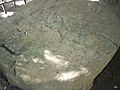
Altar 4 is a round monument found in the East Plaza with Stela 4. It shows three seated prisoners. Hieroglyphic texts are carved on it. It is from the late 8th century AD.
Burials at El Chal
Archaeologists have found several burials at El Chal. These burials give clues about the people who lived there and their customs.
Burial 67 was found under a stucco floor in Northeast Plaza Structure 2. It was an adult skeleton with pottery offerings. The pottery dates to the Late Classic.
Burial 68 was found in the center of Group 18 plaza. It was a child's burial, dating to the Late Preclassic. Pottery was also found as an offering.
Burial 265 was found at the base of a stairway in the acropolis. It contained the burial of a seated infant and a newborn. Pottery from this burial dates to the Middle Preclassic Period. This is the earliest evidence of people living at El Chal.
Images for kids
-
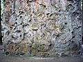
Badly eroded lower panel of Stela 4, depicting three kneeling captives
-
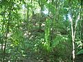
Unrestored pyramid on the acropolis
-
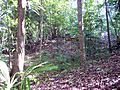
Structures on Terrace 1 of the acropolis
-
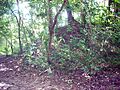
West Plaza Structure 3 seen from the East Plaza
-
The badly eroded Altar 4


See also
 In Spanish: El Chal (sitio arqueológico) para niños
