El Dorado Hills, California facts for kids
Quick facts for kids
El Dorado Hills
|
|
|---|---|
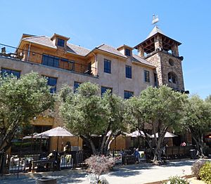
El Dorado Hills Town Center
|
|
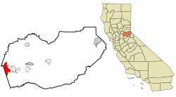
Location in El Dorado County and the state of California
|
|
| Country | |
| State | |
| County | El Dorado |
| Area | |
| • Total | 48.606 sq mi (125.888 km2) |
| • Land | 48.454 sq mi (125.494 km2) |
| • Water | 0.152 sq mi (0.394 km2) 0.31% |
| Elevation | 768 ft (234 m) |
| Population | |
| • Total | 50,547 |
| • Density | 1,039.933/sq mi (401.524/km2) |
| Time zone | UTC-8 (Pacific) |
| • Summer (DST) | UTC-7 (PDT) |
| ZIP code |
95762
|
| Area codes | 916, 279, 530 |
| FIPS code | 06-21880 |
| GNIS feature IDs | 1867020, 2408055 |
El Dorado Hills is a town in El Dorado County, California. Its name means "The Golden" in Spanish. It is located in the Greater Sacramento area of Northern California. In 2020, about 50,547 people lived there. This was a big jump from 42,108 people in 2010.
Contents
History of El Dorado Hills
During the California Gold Rush (around the mid-1800s), gold was found in rivers near El Dorado Hills. But soon, people started farming and raising animals instead of looking for gold. Some roads in El Dorado Hills today were once part of the famous Pony Express routes from 1860 to 1861. This was a mail service where riders on horses carried letters across the country very quickly.
The modern town of El Dorado Hills began in the early 1960s. A developer named Allan Lindsey wanted to create a special, planned community. The idea was to build a town where everything was carefully thought out from the start. This included homes, businesses, parks, schools, and shopping areas. The plan also made sure there was plenty of open space for outdoor activities.
From the late 1960s to the mid-1990s, El Dorado Hills grew steadily. Many families moved here from other parts of California. The town was designed with different neighborhoods, which were called "villages." Some of the first villages included Ridgeview, Park, and Saint Andrews. Later, more villages like Lake Forest and Serrano were added.
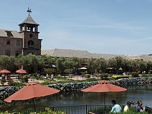
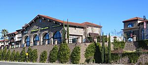
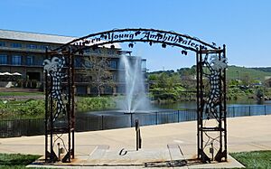
A big part of the town is the El Dorado Hills Town Center. It's a large area with shops, restaurants, and other buildings. It's a central spot for the community.
Geography and Climate
El Dorado Hills is on the western edge of El Dorado County. It's located between the city of Folsom and the community of Cameron Park. To the north, you'll find Folsom Lake and the South Fork of the American River. These are popular spots for river rafting. The area is quite large, covering about 48.6 square miles (125.9 square kilometers).
Weather in El Dorado Hills
El Dorado Hills has a Mediterranean climate. This means it has hot, dry summers and mild, wet winters. It's similar to the weather you'd find in places like the Mediterranean Sea region.
| Climate data for El Dorado Hills, 1991–2020 simulated normals (682 ft elevation) | |||||||||||||
|---|---|---|---|---|---|---|---|---|---|---|---|---|---|
| Month | Jan | Feb | Mar | Apr | May | Jun | Jul | Aug | Sep | Oct | Nov | Dec | Year |
| Mean daily maximum °F (°C) | 55.6 (13.1) |
59.9 (15.5) |
64.4 (18.0) |
70.0 (21.1) |
78.4 (25.8) |
87.4 (30.8) |
94.1 (34.5) |
93.4 (34.1) |
88.3 (31.3) |
77.9 (25.5) |
64.4 (18.0) |
55.8 (13.2) |
74.1 (23.4) |
| Daily mean °F (°C) | 47.3 (8.5) |
50.4 (10.2) |
54.0 (12.2) |
57.7 (14.3) |
64.6 (18.1) |
71.8 (22.1) |
77.4 (25.2) |
76.6 (24.8) |
72.7 (22.6) |
64.2 (17.9) |
53.8 (12.1) |
47.1 (8.4) |
61.5 (16.4) |
| Mean daily minimum °F (°C) | 39.0 (3.9) |
40.8 (4.9) |
43.3 (6.3) |
45.7 (7.6) |
50.7 (10.4) |
56.1 (13.4) |
60.6 (15.9) |
60.1 (15.6) |
57.0 (13.9) |
50.5 (10.3) |
43.2 (6.2) |
38.3 (3.5) |
48.8 (9.3) |
| Average precipitation inches (mm) | 4.71 (119.62) |
4.86 (123.38) |
4.15 (105.35) |
2.35 (59.68) |
1.40 (35.56) |
0.36 (9.14) |
0.00 (0.00) |
0.04 (0.98) |
0.15 (3.88) |
1.14 (28.88) |
2.58 (65.46) |
4.79 (121.69) |
26.53 (673.62) |
| Average dew point °F (°C) | 40.5 (4.7) |
41.4 (5.2) |
43.3 (6.3) |
44.4 (6.9) |
47.7 (8.7) |
50.4 (10.2) |
52.0 (11.1) |
50.9 (10.5) |
48.0 (8.9) |
44.2 (6.8) |
42.6 (5.9) |
39.7 (4.3) |
45.4 (7.5) |
| Source: PRISM Climate Group | |||||||||||||
People of El Dorado Hills
| Historical population | |||
|---|---|---|---|
| Census | Pop. | %± | |
| 2000 | 18,016 | — | |
| 2010 | 42,108 | 133.7% | |
| 2020 | 50,547 | 20.0% | |
| U.S. Decennial Census | |||
El Dorado Hills has grown a lot over the years. In 2000, about 18,000 people lived there. By 2010, the population was over 42,000, and in 2020, it reached more than 50,000 people!
The community is made up of people from many different backgrounds. In 2020, most residents identified as White. There were also many people who identified as Asian, and smaller groups of Black or African American, Native American, and Pacific Islander people. A growing number of people identified as being of two or more races. About 8% of the population identified as Hispanic or Latino.
Many families with children live in El Dorado Hills. The average household had about 2.9 people. Most homes are owned by the people who live in them.
Famous People from El Dorado Hills
Many talented people have lived in El Dorado Hills:
- Cimorelli – A singing group of five sisters who became famous on YouTube.
- Austin Collie – A former NFL wide receiver who played for the Indianapolis Colts.
- Ryan Anderson – An NBA power forward who played for the Houston Rockets.
- Seyi Ajirotutu – A former NFL wide receiver for the San Diego Chargers.
- Derrek Lee – A former professional baseball first baseman.
- Stephen Sanchez – A popular singer and songwriter.
- F. P. Santangelo – A former professional baseball player.
- Rick Schu – A former professional baseball player and coach.
- Joe Angel – A retired sportscaster.
- Jacoby Shaddix – The lead singer of the rock band Papa Roach.
- Cheri Elliott – A champion cyclist who won two X-Games Gold Medals. She is in the United States Bicycling Hall of Fame.
- Ian Book – A quarterback who played for the Notre Dame Fighting Irish and was drafted by the New Orleans Saints. He went to Oak Ridge High School in El Dorado Hills.
See also
 In Spanish: El Dorado Hills para niños


