El Taref Province facts for kids
Quick facts for kids
El Tarf Province
ولاية الطارف
|
|
|---|---|

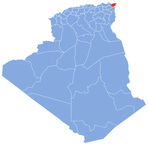
Map of Algeria highlighting El Tarf
|
|
| Country | |
| Capital | El Tarf |
| Area | |
| • Total | 3,339 km2 (1,289 sq mi) |
| Population
(2008)
|
|
| • Total | 411,783 |
| • Density | 123.325/km2 (319.41/sq mi) |
| Time zone | UTC+01 (CET) |
| Area Code | +213 (0) 38 |
| ISO 3166 code | DZ-36 |
| Districts | 7 |
| Municipalities | 24 |
El Tarf Province (Arabic: ولاية الطارف) is a special area in Algeria. It is called a wilaya, which is like a state or province. The main city and capital of this province is El Tarf.
A cool place in El Tarf Province is El Kala. It is a port town right by the sea. El Kala is also home to the amazing El Kala National Park, which is full of nature and wildlife.
Contents
History of El Tarf Province
El Tarf Province was created in 1984. Before that, its land was part of two other provinces: Annaba Province and Guelma Province.
How El Tarf Province is Organized
El Tarf Province is divided into smaller parts to help manage everything. It has 7 main areas called districts. These districts are then split into even smaller areas called municipalities. There are 24 municipalities in total.
Districts of El Tarf
Here are the 7 districts that make up El Tarf Province:
- Ben M'Hidi
- Besbes
- Bouhadjar
- Boutheldja
- Dréan
- El Kala
- El Taref
Municipalities of El Tarf
These are the 24 municipalities found within the districts of El Tarf Province:
- Ain El Assel
- Ain Kerma
- Asfour
- Ben Mehdi
- Beni Amar
- Berrihane
- Besbes
- Bougous
- Bouhadjar
- Bouteldja
- Chebaita Mokhtar
- Chefia
- Chihani
- Dréan
- El Aioun (Algeria)
- El Chatt
- El Kala
- El Taref
- Hammam Beni Salah
- Lac des Oiseaux
- Oued Zitoun
- Raml Souk Souarekh
- Zerizer
- Zitouna
See also
 In Spanish: Provincia de El Tarf para niños
 | Tommie Smith |
 | Simone Manuel |
 | Shani Davis |
 | Simone Biles |
 | Alice Coachman |

