Elizabethtown, Illinois facts for kids
Quick facts for kids
Elizabethtown, Illinois
|
|
|---|---|

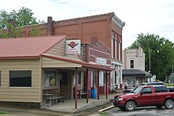
Main Street
|
|

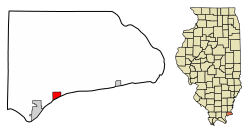
Location of Elizabethtown in Hardin County, Illinois
|
|

Location of Illinois in the United States
|
|
| Country | United States |
| State | Illinois |
| County | Hardin |
| Area | |
| • Total | 0.71 sq mi (1.84 km2) |
| • Land | 0.70 sq mi (1.83 km2) |
| • Water | 0.01 sq mi (0.01 km2) |
| Elevation | 367 ft (112 m) |
| Population
(2020)
|
|
| • Total | 220 |
| • Density | 312.06/sq mi (120.41/km2) |
| Time zone | UTC-6 (CST) |
| • Summer (DST) | UTC-5 (CDT) |
| ZIP Code(s) |
62931
|
| Area code(s) | 618 |
| FIPS code | 17-23191 |
| GNIS ID | 2398801 |
Elizabethtown is a small village in Hardin County, Illinois, United States. It is the main town, or county seat, of Hardin County. The village is located right next to the beautiful Ohio River. In 2020, about 220 people lived there. This makes it the smallest county seat in all of Illinois!
History of Elizabethtown
Elizabethtown has a long and interesting history. One of the first people to settle here was James McFarland. He arrived around 1809. The village officially started in 1812, built around a tavern that James McFarland owned.
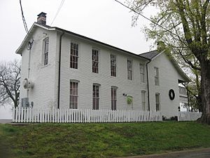
This tavern later became the famous Rose Hotel. It was named after its owner, Sarah Rose. For many years, until the 1960s, the Rose Hotel was the oldest hotel in Illinois that was always open. Today, it is a special state historic site.
The village of Elizabethtown was named after James McFarland's wife, Elizabeth. Another important historical site is the First Baptist Church. It was founded in 1806. This makes it the oldest Baptist church in Illinois. It is also known as the oldest Protestant church in the state.
Locally, people often call Elizabethtown "Etown". You can even see this nickname in the name of a restaurant downtown, the E'town River Restaurant.
Geography and Location
Elizabethtown is found in the southern part of Hardin County. It is located at 37°26′57″N 88°18′13″W / 37.44917°N 88.30361°W. The village sits right on the Ohio River. This river forms the border between Illinois and Kentucky.
Illinois Route 146 is a main road that goes through Elizabethtown. If you travel southwest on this road, you will reach Golconda in about 15 miles. If you go east, you'll find Illinois Route 1 and Cave-In-Rock about 9 miles away.
To get to Rosiclare, which is the only city in Hardin County, you can drive 2.5 miles west on IL-146. Then, turn south on IL-34 for about 2 miles. The total area of Elizabethtown is about 0.71 square miles (1.84 square kilometers). Most of this area is land, with a very small part being water.
Population of Elizabethtown
| Historical population | |||
|---|---|---|---|
| Census | Pop. | %± | |
| 1880 | 484 | — | |
| 1890 | 652 | 34.7% | |
| 1900 | 668 | 2.5% | |
| 1910 | 633 | −5.2% | |
| 1920 | 1,055 | 66.7% | |
| 1930 | 488 | −53.7% | |
| 1940 | 622 | 27.5% | |
| 1950 | 583 | −6.3% | |
| 1960 | 524 | −10.1% | |
| 1970 | 436 | −16.8% | |
| 1980 | 478 | 9.6% | |
| 1990 | 427 | −10.7% | |
| 2000 | 348 | −18.5% | |
| 2010 | 299 | −14.1% | |
| 2020 | 220 | −26.4% | |
| U.S. Decennial Census | |||
According to the 2020 census, there were 220 people living in Elizabethtown. These people made up 188 households. The village has seen its population change over the years, as shown in the table above.
Most of the people living in Elizabethtown are White. A small number of residents are African American, Asian, or from two or more races. A very small percentage of the population is Hispanic or Latino.
About 13.8% of the households in Elizabethtown have children under 18 living with them. Many households (75%) are made up of individuals living alone. About 42.55% of these individuals are 65 years old or older.
The average age of people in Elizabethtown is about 59.1 years old. This means there are more older adults living in the village.
See also
 In Spanish: Elizabethtown (Illinois) para niños
 | Georgia Louise Harris Brown |
 | Julian Abele |
 | Norma Merrick Sklarek |
 | William Sidney Pittman |


