Ellicott's Rock facts for kids
Quick facts for kids |
|
|
Ellicott Rock
|
|
| Nearest city | Walhalla, South Carolina |
|---|---|
| Area | 0.5 acres (0.20 ha) |
| Built | 1813 |
| NRHP reference No. | 73001722 |
| Added to NRHP | 1973 |
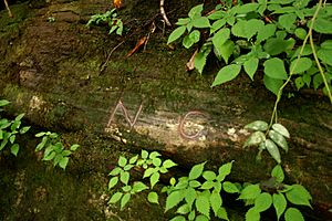
Ellicott's Rock is a special stone marker placed in 1811 by a surveyor named Andrew Ellicott. He put it there to help solve a big argument about where the border was between the U.S. states of Georgia and North Carolina.
This border argument even led to a small fight called the Walton War. After that, Georgia hired Ellicott to survey the land again. He carved "N-G" (for North Carolina - Georgia) into a large rock in the Chattooga River. This spot was chosen because of an earlier agreement from 1787, which mentioned a river that flows into the Savannah River between Georgia and South Carolina. The U.S. Congress later said the border should be at 35°N latitude.
Contents
The Other Important Rock
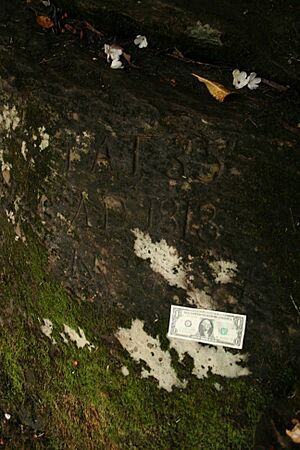
Two years after Ellicott's survey, in 1813, other officials from North Carolina and South Carolina marked a different large rock. This rock is also along the Chattooga River. They carved "Lat 35 AD 1813 NC + S.C." into it.
Why There Are Two Rocks
Many people often confuse this second rock with Ellicott's original one. They might call it "Ellicott Rock" by mistake. To make it clearer, this second rock is also known as Commissioners Rock. It is now generally accepted as the meeting point where the borders of South Carolina, North Carolina, and Georgia all come together. This kind of meeting point is called a tripoint.
How Far Apart Are They?
There are different ideas about how far apart these two rocks are. One story says Ellicott's original rock is about 150 meters (500 feet) upstream from the Commissioners Rock. Another story says they are much closer. One guide says they are "a few feet apart," while another says Commissioners Rock is "ten feet downstream."
Ellicott Rock's History
Ellicott's Rock was added to the National Register of Historic Places in 1973. This means it's an important historical site. It is located in a special protected area called the Ellicott Rock Wilderness.
The Border Is Not Perfect
It turns out that neither Ellicott's Rock nor the Commissioners Rock is exactly on the 35th parallel north, which is the line Congress wanted. The actual 35th parallel is about 70 meters (230 feet) south of Ellicott Rock. You can even see this on Google Maps.
Why the Border Is Crooked
Further west, the border is even more off, by over a mile! This mistake created the only big bend in what should have been a straight border between North Carolina and Georgia. The only place where the border is truly at 35°N is at the Mississippi River.
This error affected other states too, like Tennessee (which was once part of North Carolina) and parts of Alabama and Mississippi. The mistake happened because Georgia supposedly didn't give Ellicott the right surveying equipment. Because Georgia didn't complain about the mistake for a long time, the border stayed that way. This old error even causes a modern argument about water in the Tennessee River near Chattanooga. A small part of Nickajack Lake would have been in Georgia if Ellicott's survey had been perfect.
 | Frances Mary Albrier |
 | Whitney Young |
 | Muhammad Ali |


