Walhalla, South Carolina facts for kids
Quick facts for kids
Walhalla
|
|||
|---|---|---|---|

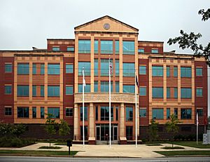
Oconee County Courthouse
|
|||
|
|||

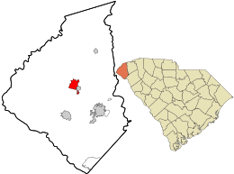
Location in Oconee County and the state of South Carolina.
|
|||
| Country | United States | ||
| State | South Carolina | ||
| County | Oconee | ||
| First settled | 1848 | ||
| Area | |||
| • Total | 3.95 sq mi (10.22 km2) | ||
| • Land | 3.88 sq mi (10.06 km2) | ||
| • Water | 0.06 sq mi (0.16 km2) | ||
| Elevation | 1,027 ft (313 m) | ||
| Population
(2020)
|
|||
| • Total | 4,072 | ||
| • Density | 1,048.13/sq mi (404.68/km2) | ||
| Time zone | UTC−5 (Eastern (EST)) | ||
| • Summer (DST) | UTC−4 (EDT) | ||
| ZIP code |
29691
|
||
| FIPS code | 45-74095 | ||
| GNIS feature ID | 1230451 | ||
Walhalla is a city in the beautiful Blue Ridge Mountains foothills in Oconee County, South Carolina. It was chosen as the county seat in 1868. The city is located in an area where mountains meet flatter land, which means it has many amazing waterfalls. It's also about 16 miles (26 km) from Clemson University.
This city was founded by European-Americans after the Cherokee people were moved from the area in 1838. Many of the first people to live here were German immigrants. They had left Germany because of problems there in 1848-1849. Some English and Scotch-Irish farmers also came to settle here.
In 1868, during a time called the Reconstruction era, Oconee County was officially formed. The state government decided that Walhalla would be its main city, or county seat.
In 2020, about 4,072 people lived in Walhalla. However, when people talk about "Walhalla," they often mean a larger area, including the surrounding communities that share the same zip code (29691). This larger area has more people living in it.
Contents
History of Walhalla
How Walhalla Was Founded
A group called the German Colonization Society of Charleston was started in 1848. Its goal was to help German immigrants settle in Upstate South Carolina. Many of these immigrants were farmers and business owners who had to leave Germany after the German revolutions of 1848-1849.
In 1849, leaders of the Society bought a large piece of land, about 17,859 acres (72.27 km2), for $27,000. They bought it from a reverend named Joseph Grisham. This land was meant to be a new home for the German settlers.
The Name Walhalla
The German colonists were often political refugees, meaning they had to leave their home country for political reasons. They named their new settlement "Walhalla." This name comes from Norse Mythology, where Valhalla is a grand hall. In Norse myths, brave warriors who died in battle would go to Valhalla.
Many of the German settlers sailed from Hamburg, Germany, to Charleston. Most of them were from a part of Germany called Bavaria. Some English and Scots-Irish immigrants also came on the same ships.
Walhalla Becomes a County Seat
When Oconee County was created in 1868, Walhalla was chosen as its county seat. After this, more people from other places, especially former British settlers from nearby counties like Pickens and Anderson, moved to Walhalla. This meant that the original German population became a smaller part of the city's total population.
Important Historic Places
Several important places in Walhalla are listed on the National Register of Historic Places. This means they are special and protected because of their history. These include:
- Ellicott Rock
- Keil Farm
- Oconee County Cage
- Oconee Station and Richards House
- St. John's Lutheran Church
- Stumphouse Tunnel Complex
- Walhalla Graded School
In 1988, Walhalla made history by electing its first (and only) female mayor, Gladys Pepper.
Geography and Climate
Where is Walhalla Located?
Walhalla is located at 34.767263 degrees North latitude and -83.064321 degrees West longitude. It is in the northwestern part of South Carolina, close to the borders of Georgia and North Carolina. Two main roads, South Carolina Highway 28 and South Carolina Highway 183, cross paths here. The small town of West Union is right next to Walhalla on its east side.
The United States Census Bureau says that Walhalla covers a total area of about 3.8 square miles (9.8 km2). Most of this area, about 3.7 square miles (9.6 km2), is land. A small part, about 0.1 square miles (0.26 km2), is water.
Ground and Earthquakes
The town of Walhalla is mostly built on hard granite rock. Because it is near some small cracks in the Earth's crust called faults, it has had a few small earthquakes. These earthquakes are not very common.
The last earthquake near Walhalla happened on May 19, 1971. Its center, called the epicenter, was in Newry, South Carolina. This earthquake was rated as "strong" (Intensity VI) on the Mercalli intensity scale, which measures how much an earthquake is felt by people and how much damage it causes. Scientists believe this earthquake was caused by movement along the Brevard Fault and other faults in the area. The huge weight of the man-made Lake Keowee, created by the Keowee Dam, might have also played a part.
The Stumphouse Mountain Tunnel is a famous landmark located close to Walhalla.
Walhalla's Weather
Walhalla has a climate with warm summers and mild winters. Here's a look at the average temperatures and rainfall:
| Climate data for Walhalla, South Carolina (1991–2020 normals, extremes 1896–present) | |||||||||||||
|---|---|---|---|---|---|---|---|---|---|---|---|---|---|
| Month | Jan | Feb | Mar | Apr | May | Jun | Jul | Aug | Sep | Oct | Nov | Dec | Year |
| Record high °F (°C) | 81 (27) |
82 (28) |
94 (34) |
94 (34) |
101 (38) |
105 (41) |
106 (41) |
106 (41) |
108 (42) |
98 (37) |
87 (31) |
81 (27) |
108 (42) |
| Mean daily maximum °F (°C) | 51.7 (10.9) |
55.7 (13.2) |
63.1 (17.3) |
72.2 (22.3) |
78.9 (26.1) |
85.4 (29.7) |
88.5 (31.4) |
87.3 (30.7) |
81.8 (27.7) |
71.7 (22.1) |
62.0 (16.7) |
53.9 (12.2) |
71.0 (21.7) |
| Daily mean °F (°C) | 40.5 (4.7) |
43.3 (6.3) |
50.1 (10.1) |
58.4 (14.7) |
66.7 (19.3) |
74.2 (23.4) |
77.5 (25.3) |
76.6 (24.8) |
71.0 (21.7) |
59.8 (15.4) |
49.4 (9.7) |
42.9 (6.1) |
59.2 (15.1) |
| Mean daily minimum °F (°C) | 29.2 (−1.6) |
30.9 (−0.6) |
37.1 (2.8) |
44.7 (7.1) |
54.5 (12.5) |
63.1 (17.3) |
66.5 (19.2) |
66.0 (18.9) |
60.1 (15.6) |
47.8 (8.8) |
36.8 (2.7) |
31.8 (−0.1) |
47.4 (8.6) |
| Record low °F (°C) | −5 (−21) |
−4 (−20) |
3 (−16) |
20 (−7) |
28 (−2) |
39 (4) |
49 (9) |
49 (9) |
32 (0) |
20 (−7) |
9 (−13) |
−3 (−19) |
−5 (−21) |
| Average precipitation inches (mm) | 5.43 (138) |
4.78 (121) |
5.17 (131) |
4.75 (121) |
4.79 (122) |
5.25 (133) |
4.93 (125) |
6.17 (157) |
4.89 (124) |
4.60 (117) |
4.54 (115) |
5.80 (147) |
61.10 (1,552) |
| Average snowfall inches (cm) | 0.8 (2.0) |
0.7 (1.8) |
0.2 (0.51) |
0.0 (0.0) |
0.0 (0.0) |
0.0 (0.0) |
0.0 (0.0) |
0.0 (0.0) |
0.0 (0.0) |
0.0 (0.0) |
0.0 (0.0) |
0.5 (1.3) |
2.2 (5.6) |
| Average precipitation days (≥ 0.01 in) | 10.1 | 9.6 | 10.7 | 9.6 | 10.5 | 11.6 | 12.0 | 12.3 | 8.9 | 7.8 | 8.6 | 10.5 | 122.2 |
| Average snowy days (≥ 0.1 in) | 0.5 | 0.3 | 0.2 | 0.0 | 0.0 | 0.0 | 0.0 | 0.0 | 0.0 | 0.0 | 0.0 | 0.4 | 1.4 |
| Source: NOAA | |||||||||||||
People of Walhalla
Population Changes Over Time
The number of people living in Walhalla has changed quite a bit over the years. Here's a quick look at the population from 1870 to 2020:
| Historical population | |||
|---|---|---|---|
| Census | Pop. | %± | |
| 1870 | 716 | — | |
| 1880 | 789 | 10.2% | |
| 1890 | 820 | 3.9% | |
| 1900 | 1,307 | 59.4% | |
| 1910 | 1,595 | 22.0% | |
| 1920 | 2,068 | 29.7% | |
| 1930 | 2,388 | 15.5% | |
| 1940 | 2,820 | 18.1% | |
| 1950 | 3,104 | 10.1% | |
| 1960 | 3,431 | 10.5% | |
| 1970 | 3,662 | 6.7% | |
| 1980 | 3,977 | 8.6% | |
| 1990 | 3,755 | −5.6% | |
| 2000 | 3,801 | 1.2% | |
| 2010 | 4,263 | 12.2% | |
| 2020 | 4,072 | −4.5% | |
| U.S. Decennial Census | |||
Walhalla's Population in 2020
According to the 2020 United States census, there were 4,072 people living in Walhalla. These people made up 1,668 households and 1,202 families.
Here's a breakdown of the different groups of people living in Walhalla in 2020:
| Race | Num. | Perc. |
|---|---|---|
| White (non-Hispanic) | 2,626 | 64.49% |
| Black or African American (non-Hispanic) | 168 | 4.13% |
| Native American | 12 | 0.29% |
| Asian | 19 | 0.47% |
| Pacific Islander | 3 | 0.07% |
| Other/Mixed | 206 | 5.06% |
| Hispanic or Latino | 1,038 | 25.49% |
Education in Walhalla
Walhalla has a lending library where you can borrow books. It's a part of the Oconee County Public Library system. The city is also home to Walhalla Middle School and James M. Brown Elementary School. Just outside the city limits, you'll find Walhalla High School and Walhalla Elementary School.
Arts and Culture in Walhalla
Oktoberfest Celebration
Because of its strong German heritage, Walhalla holds an annual Oktoberfest celebration. This fun festival starts on the third Friday of October every year. It takes place on Main Street (Highway 28) and at the city's Sertoma Field (near Highway 183).
The Oktoberfest festival is a big event! It features:
- Art and craft vendors selling unique items.
- Live music and dancing.
- Special food vendors offering tasty treats.
- Exciting carnival rides.
- Many other festive activities for everyone to enjoy.
Merchant Market
Walhalla also hosts a Merchant Market each year. This market happens shortly after Oktoberfest ends. Many local businesses set up stalls on Main Street to sell food and gifts.
Notable People from Walhalla
Many interesting people have connections to Walhalla, including:
- John C. Portman Jr., a famous architect.
- Cornelia Strong, a talented mathematician and astronomer.
- Thomas C. Alexander, who is the president of the South Carolina State Senate.
- Dutch Mantell, a well-known professional wrestler.
- Reuben Shannon Lovinggood (1864–1916), an important educator and college president.
See also
In Spanish: Walhalla (Carolina del Sur) para niños
 | Mary Eliza Mahoney |
 | Susie King Taylor |
 | Ida Gray |
 | Eliza Ann Grier |


