Elmira, Missouri facts for kids
Quick facts for kids
Elmira, Missouri
|
|
|---|---|
|
Village
|
|
| Nickname(s):
Elmira Bluejays
|
|

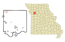
Location of Elmira, Missouri
|
|
| Country | United States |
| State | Missouri |
| County | Ray |
| Area | |
| • Total | 0.07 sq mi (0.19 km2) |
| • Land | 0.07 sq mi (0.19 km2) |
| • Water | 0.00 sq mi (0.00 km2) |
| Elevation | 942 ft (287 m) |
| Population
(2020)
|
|
| • Total | 39 |
| • Density | 534.25/sq mi (207.22/km2) |
| Time zone | UTC-6 (Central (CST)) |
| • Summer (DST) | UTC-5 (CDT) |
| ZIP code |
64062
|
| Area code(s) | 816 |
| FIPS code | 29-22006 |
| GNIS feature ID | 2398814 |
Elmira is a small village located in the northwest part of Ray County, Missouri. It is part of the larger Kansas City metropolitan area. In 2020, only 39 people lived there, making it a very tiny community!
Contents
Elmira's History
Elmira started as a place where people dug for valuable minerals. This means it was a mining settlement. The village was officially planned and marked out in 1887. It was named after a city called Elmira, New York.
A post office opened in Elmira in 1887. This helped people send and receive mail. The post office stayed open until 1959.
An important historical event happened close to Elmira. The Battle of Crooked River was fought about two miles southeast of the village. This battle was part of the Mormon War in 1838.
Where is Elmira?
Elmira is located in the United States. According to the United States Census Bureau, the village covers a total area of about 0.07 square miles (0.19 square kilometers). All of this area is land, with no water.
Who Lives in Elmira?
| Historical population | |||
|---|---|---|---|
| Census | Pop. | %± | |
| 1930 | 187 | — | |
| 1940 | 159 | −15.0% | |
| 1950 | 128 | −19.5% | |
| 1960 | 123 | −3.9% | |
| 1970 | 124 | 0.8% | |
| 1980 | 109 | −12.1% | |
| 1990 | 70 | −35.8% | |
| 2000 | 82 | 17.1% | |
| 2010 | 50 | −39.0% | |
| 2020 | 39 | −22.0% | |
| U.S. Decennial Census | |||
The number of people living in Elmira has changed over the years. In 1930, there were 187 residents. By 2020, the population had decreased to 39 people.
Elmira's Population in 2010
In 2010, the census counted 50 people living in Elmira. These people lived in 18 different homes, called households. Out of these, 14 were families.
The population density was about 714 people per square mile (276 people per square kilometer). This tells us how many people live in a certain amount of space. There were 22 housing units in total.
Most of the people in Elmira were White, making up 90% of the population. About 2% were from other races. Another 8% were from two or more races. About 8% of the population identified as Hispanic or Latino.
Out of the 18 households, 22.2% had children under 18 living with them. Most households, 66.7%, were married couples living together. About 11.1% had a male householder living without a wife. Also, 22.2% of all households were made up of individuals living alone. About 11.2% of these individuals were 65 years old or older.
The average household had about 2.78 people. The average family had about 3.07 people.
The median age in the village was 47.5 years old. This means half the people were younger than 47.5 and half were older. About 12% of residents were under 18. About 8% were between 18 and 24 years old. A larger group, 28%, was between 25 and 44. The biggest group, 44%, was between 45 and 64. Finally, 8% were 65 years old or older.
When looking at gender, 54% of the village's population was male. The other 46% was female.
See also
 In Spanish: Elmira (Misuri) para niños

