
Els Límits facts for kids
Quick facts for kids
Els Límits
|
|
|---|---|
|
Village
|
|

View of the French town of Le Perthus from the Fort de Bellegarde. Els Límits is in the right side
|
|
.PNG)
Els Límits (black dot) in la La Jonquera municipality (orange) within the Province of Girona. Spanish map in the corner shows the province of Girona (blue) and the rest of Catalonia (red)
|
|

Els Límits
Location in Spain
|
|
| Country | |
| Community | |
| Province | |
| Comarca | |
| Municipality | |
| Elevation | 250 m (820 ft) |
| Population | |
| • Total | 115 |
| Time zone | UTC+1 (CET) |
| • Summer (DST) | UTC+2 (CEST) |
| Postal code |
17700
|
| Area code(s) | (+34) ... |
| Demonym | Limiters (Ca) Limiteros (Es) |

Els Límits is a small village in Spain, located in the province of Girona, Catalonia. It's part of the La Jonquera area. In 2005, about 115 people lived there. Its name in Spanish is Los Límites, which means "The Borders."
Contents
History of the Border Village
The story of how Els Límits became a divided village started a long time ago. In the 1600s, after a war between France and Spain, a special agreement called the Treaty of the Pyrenees was signed. This treaty decided where the border between the two countries would be. It was set along the Pyrenees mountains.
Geography and Location

Els Límits is right on the border with France, specifically near the Languedoc-Roussillon region. It's also close to an old historical area called Vallespir.
This village has a French "twin town" called Le Perthus. Le Perthus is located to the north and west of Els Límits. They are so close that one of the main roads, Avinguda d'Espanya, is actually in both Spain and France! The part of the road in France is called Avenue de France.
Besides this main road, other important streets include Carrer del Doctor Subiros, Calle del Correc (which is also in both countries), Carrer de Fàtima, and Carrer d'Hannibal.
Els Límits is not far from other cities:
- It's about 5 kilometers (3 miles) from La Jonquera.
- It's about 27 kilometers (17 miles) from Figueres.
- It's about 35 kilometers (22 miles) from Perpignan/Perpinyà in France.
- It's about 63 kilometers (39 miles) from Girona.
- It's about 160 kilometers (99 miles) from Barcelona.
Village Photo Gallery
-
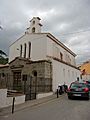
The Sanctuary of Fàtima
-
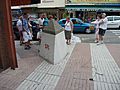
The border line on the central "Avenue de France" (Le Perthus, right) and "Avinguda d'Espanya" (Els Límits, left)
-
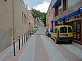
The international road "Rue du Petit Pont" (Le Perthus, left) and "Carrer del Còrrec" (Els Límits, right)


Economy and Trade
Because Els Límits is a border town, its economy is mostly about trade. Many shops here sell things like drinks, tobacco, and other products. These items are often cheaper in Spain than in France. In the past, both Els Límits and Le Perthus were known for trading goods across the border without paying the usual taxes.
Transportation and Roads
Els Límits does not have a train station. However, it is crossed by an important national road called N-II. This road continues into France as Route nationale 9 (RN9).
There's also a major highway nearby. The AP-7 in Spain goes from La Jonquera to cities like Barcelona, Valencia, Alicante, and Vera. This highway becomes the A9 in France, connecting Le Perthus to Perpignan, Montpellier, and Orange. The closest highway exits are "La Jonquera" for the AP-7 and "Le Boulou" for the A9.
See also
 In Spanish: El Portús (Gerona) para niños
