Elstree Rural District facts for kids
| Elstree Rural District Barnet Rural District (1894–1941) |
|
| Motto: Do well and fear not | |
| Geography | |
| 1911 area | 10,820 acres (43.8 km2) |
| 1974 area | 8,339 acres (33.75 km2) |
| HQ | Council Offices, Shenley Road, Borehamwood |
| History | |
| Created | 28 December 1894 |
| Abolished | 31 March 1974 |
| Succeeded by | Hertsmere |
Quick facts for kids Demography |
|
|---|---|
| 1901 population | 4,154 |
| 1971 population | 31,565 |
The Elstree Rural District was a local government area in Hertfordshire, England. It existed from 1894 until 1974. Before 1941, it was known as the Barnet Rural District. This district helped manage local services and rules for the towns and villages in its area.
Contents
How Elstree Rural District Started
The story of the Elstree Rural District began in 1872. Back then, there was something called the Barnet Rural Sanitary District. This group looked after health and cleanliness in the countryside around Barnet.
In 1894, a new law called the Local Government Act 1894 changed things. It turned these "sanitary districts" into "rural districts." If a district crossed county lines, it was split. The Barnet area was in both Hertfordshire and Middlesex. So, the part in Middlesex became the South Mimms Rural District. The part in Hertfordshire became the Barnet Rural District.
Also, some towns were split. The old town of Chipping Barnet was divided. Its rural part became a new area called Arkley. This new Barnet Rural District officially started on 28 December 1894. Later, on 28 July 1941, the district changed its name to the Elstree Rural District.
Local Areas and Changes Over Time
Over the years, the Elstree Rural District included several smaller areas called civil parishes. These were:
- Arkley (from 1894 to 1905)
- Elstree (from 1894 to 1974)
- Ridge (from 1894 to 1974)
- Shenley (from 1894 to 1974)
- Totteridge (from 1894 to 1914)
Arkley became part of the Barnet Urban District in 1905. This meant Totteridge was left as a separate piece of the Barnet Rural District, not connected to the main part. Nine years later, in 1914, Totteridge also joined the Barnet Urban District.
In 1935, some boundaries were changed again. Parts of Elstree, Ridge, and Shenley were moved to the Barnet Urban District. Some land from Ridge and Shenley went to the St Albans Rural District. At the same time, the Elstree Rural District gained land from Aldenham, which came from the Watford Rural District.
Where the Council Met
When the Barnet Rural District Council first started, its meetings were held in the Barnet Union Workhouse. This was a building at 17 Wellhouse Lane in Barnet. Their first meeting was on 3 January 1895. A farmer named John Osmond became their first chairman.
The council met at the workhouse until 1929. At that time, the hospital needed more space, so the council had to find a new home. They moved to Borehamwood, which was growing quickly. This was partly because of the famous Elstree Studios nearby.
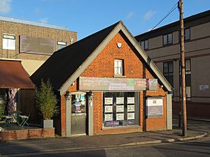
The council bought an old Baptist Chapel at 1 Station Road. This building had even been a cinema called "The Gem" for a short time. However, it was a bit small, so some of the council's work was done at the office of their solicitor, who worked nearby. Later, the council moved to even newer offices at 84 Shenley Road. These were built on what used to be tennis courts.
The District's Coat of Arms
On 20 March 1957, the Elstree Rural District was given its own special coat of arms. This coat of arms had many symbols, each with a meaning:
- The background was royal ermine, which is a pattern like a royal cloak. This showed the district's connection to kings and queens, like King Henry VIII and King Charles II, who visited the area.
- An oak tree with a Saxon crown represented the old Saxon name for Elstree, "Tidwulf's tree." It also stood for the woodlands in the area, like Boreham Wood. The gold acorns on the tree symbolized growth and success.
- Wavy lines at the bottom represented the River Colne and Aldenham Reservoir. They also linked to the wavy lines on the coat of arms of Hertfordshire County Council.
- A gold X-shape on a blue background came from the arms of the Abbey of St. Albans. This showed that the Abbey once owned land in Elstree.
- Scallop shells were a symbol for pilgrims, reminding people that pilgrims used to travel through Elstree on Watling Street to St. Albans.
- A hart (a type of deer) from the County Council's arms wore a special crown, showing local government.
- A spool of film was a unique symbol. It showed the important film industry in Elstree and Borehamwood, which made the area famous.
- The motto, "Do well and fear not," was taken from a wall in Shenley and also connected to the county's motto.
The End of the District
The Elstree Rural District came to an end on 1 April 1974. This happened because of the Local Government Act 1972, which changed how local government worked across England. The area of the Elstree Rural District became part of a new, larger district called Hertsmere.
The council's old offices at 84 Shenley Road in Borehamwood were later redeveloped. They became a Tesco supermarket, and then in the late 1990s, they were turned into a cinema and leisure complex.
 | Charles R. Drew |
 | Benjamin Banneker |
 | Jane C. Wright |
 | Roger Arliner Young |


