Emerald, Washington
Quick facts for kids
Emerald, Washington
|
|
|---|---|
| Country | United States |
| State | Washington |
| County | Yakima |
| Elevation | 722 ft (220 m) |
| Time zone | UTC-8 (Pacific (PST)) |
| • Summer (DST) | UTC-7 (PDT) |
| ZIP code |
98944
|
| Area code(s) | 509 |
| GNIS feature ID | 1510944 |
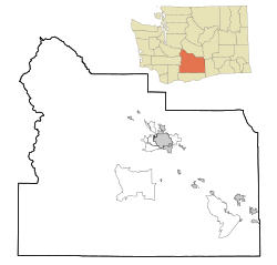
Emerald is a small, quiet place located in Yakima County, Washington, in the United States. It is known as an unincorporated community. This means it doesn't have its own local government, like a city or town would. Instead, it is managed directly by Yakima County.
Emerald is situated about 2 miles (3.2 kilometers) west of a larger town called Sunnyside.
Contents
Discovering Emerald's Location
Emerald is found in the beautiful state of Washington. This state is in the Pacific Northwest region of the United States. Emerald is part of Yakima County, which is one of the largest counties in Washington.
Where is Emerald on the Map?
You can find Emerald by looking for its special geographic coordinates. These are like a unique address for any spot on Earth. Emerald's coordinates are 46.3026306 degrees North and 120.0814345 degrees West.
How High is Emerald?
Emerald sits at an elevation of about 220 meters (or 722 feet) above sea level. This means it's quite a bit higher than the ocean.
Time and Communication in Emerald
Like many places, Emerald follows a specific time zone. It is in the Pacific Time Zone.
What Time Zone is Emerald In?
During most of the year, Emerald uses Pacific Standard Time (PST). This is 8 hours behind Coordinated Universal Time (UTC-8). In the summer, it switches to Pacific Daylight Time (PDT). This means the clocks move forward one hour (UTC-7).
How Do People Communicate?
If you wanted to send a letter to Emerald, you would use the ZIP code 98944. For phone calls, the area code for Emerald and the surrounding region is 509.


