Emily, Minnesota facts for kids
Quick facts for kids
Emily
|
|
|---|---|

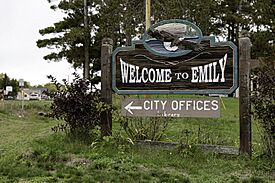
Welcome to Emily sign
|
|
| Motto(s):
"Land Of Lakes & Pines"
|
|

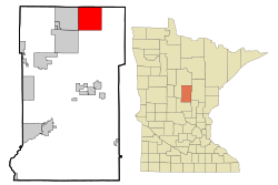
Location of Emily
within Crow Wing County, Minnesota |
|
| Country | United States |
| State | Minnesota |
| County | Crow Wing |
| Platted | November 22, 1905 |
| Incorporated | March 7, 1957 |
| Area | |
| • Total | 36.06 sq mi (93.39 km2) |
| • Land | 29.98 sq mi (77.65 km2) |
| • Water | 6.08 sq mi (15.74 km2) |
| Elevation | 1,293 ft (394 m) |
| Population
(2020)
|
|
| • Total | 843 |
| • Estimate
(2022)
|
862 |
| • Density | 28.12/sq mi (10.86/km2) |
| Time zone | UTC−6 (Central (CST)) |
| • Summer (DST) | UTC−5 (CDT) |
| ZIP Code |
56447
|
| Area code(s) | 218 |
| FIPS code | 27-19286 |
| GNIS feature ID | 2394686 |
| Sales tax | 7.375% |
Emily is a small city located in Crow Wing County, Minnesota, United States. It's known for its many lakes and beautiful pine forests. The city's motto, "Land Of Lakes & Pines," truly describes its natural beauty. In 2020, about 843 people called Emily home. The city is also part of the larger Brainerd area.
You can reach Emily using Minnesota State Highway 6 and Crow Wing County Road 1.
Contents
A Look Back at Emily's History
Emily is named after the nearby Emily Lake. The city's land was first officially marked out and planned on November 22, 1905. This process is called being "platted."
Later, on March 7, 1957, Emily officially became an "incorporated" city. This means it gained its own local government. The first post office in Emily opened even earlier, in the year 1900.
Emily's Location and Landscape
Emily is located in the northeastern part of Crow Wing County. The city covers an area of about 36 square miles (93 square kilometers).
Most of this area, about 30 square miles (78 square kilometers), is land. The rest, about 6 square miles (16 square kilometers), is covered by water. This shows how important lakes and water bodies are to the city's geography.
Who Lives in Emily? A Look at the Population
The population of Emily has changed over the years. Here's how many people have lived in the city according to different censuses:
| Historical population | |||
|---|---|---|---|
| Census | Pop. | %± | |
| 1960 | 351 | — | |
| 1970 | 386 | 10.0% | |
| 1980 | 588 | 52.3% | |
| 1990 | 613 | 4.3% | |
| 2000 | 847 | 38.2% | |
| 2010 | 813 | −4.0% | |
| 2020 | 843 | 3.7% | |
| 2022 (est.) | 862 | 6.0% | |
| U.S. Decennial Census 2020 Census |
|||
Emily's Population in 2010
In 2010, the census showed that 813 people lived in Emily. These people made up 368 households. A household is a group of people living together in one home.
Most households, 237 of them, were families. The city had about 27 people living per square mile. There were also many homes available, with about 35 housing units per square mile.
Racial Backgrounds in Emily
In 2010, most of Emily's residents were White, making up 97.4% of the population. A small number of residents were African American or Native American. About 2% of the population identified with two or more racial backgrounds.
People of Hispanic or Latino origin made up less than 1% of the population.
Households and Families
Out of the 368 households, about 18.5% had children under 18 living with them. More than half, 54.6%, were married couples living together. A small number of households were led by a single female or male parent.
About 35.6% of households were "non-families," meaning they were individuals living alone or groups of unrelated people. Many people, 14.9%, lived alone and were 65 years old or older.
Age Groups in Emily
The average age of people in Emily in 2010 was 52.8 years. About 18.3% of residents were under 18 years old. This means Emily has a smaller percentage of young people compared to some other places.
About 30.1% of the population was 65 years old or older. This shows that Emily is a popular place for older adults. The population was almost evenly split between males (50.4%) and females (49.6%).
See also
 In Spanish: Emily (Minnesota) para niños

