Emperor Peak facts for kids
Quick facts for kids Emperor Peak |
|
|---|---|

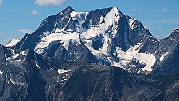
Emperor-Archduke Massif, northeast aspect
Emperor Peak (right) |
|
| Highest point | |
| Elevation | 3,127 m (10,259 ft) |
| Prominence | 77 m (253 ft) |
| Parent peak | Archduke Mountain (3135 m) |
| Geography | |
| Location | British Columbia, Canada |
| Parent range | Purcell Mountains |
| Topo map | NTS 82K/7 |
| Climbing | |
| First ascent | 1967 |
Emperor Peak is a tall mountain in the Purcell Mountains of British Columbia, Canada. It stands at 3,127-metre (10,259-foot) high. This peak is about 43 km (27 mi) north of a town called Kaslo. It sits right on the northern edge of the Purcell Wilderness Conservancy Provincial Park and Protected Area.
Emperor Peak is very close to another mountain called Archduke Mountain. Archduke Mountain is just 1 km (0.62 mi) to the east and is slightly taller. These two mountains together form a large double-peaked area known as the Archduke-Emperor massif. The name "Emperor Peak" was officially chosen on June 20, 1972. It was approved by the Geographical Names Board of Canada. The peak was named because it looks very grand and important, like an emperor. It was also named after Beethoven's famous Emperor Concerto. This name was suggested by a climber named Curt Wagner, who climbed the mountain in 1967.
What's the Weather Like at Emperor Peak?
Emperor Peak is in a subarctic climate zone. This means it has very cold and snowy winters. The summers are usually mild, not too hot. Temperatures can often drop below −20 °C (that's −4 °F). With the wind chill, it can feel even colder, sometimes below −30 °C (−22 °F).
Water from the Mountain
The water from rain and melting snow on Emperor Peak flows into small streams. These streams then join larger rivers. All the water from Emperor Peak and its glacier eventually drains into the Duncan River.
 | Victor J. Glover |
 | Yvonne Cagle |
 | Jeanette Epps |
 | Bernard A. Harris Jr. |


