
Emperor Peak (Alaska) facts for kids
Quick facts for kids Emperor Peak |
|
|---|---|

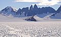
Emperor Peak centered, from southeast
(Princess Peak left, Taku Towers right) |
|
| Highest point | |
| Elevation | 6,805 ft (2,074 m) |
| Prominence | 1,705 ft (520 m) |
| Isolation | 4.32 mi (6.95 km) |
| Parent peak | The Snow Towers |
| Geography | |

Emperor Peak
Location in Alaska
|
|
| Location | Tongass National Forest Juneau Borough Alaska, United States |
| Parent range | Coast Mountains Boundary Ranges Juneau Icefield |
| Topo map | USGS Juneau C-2 |
Emperor Peak is a tall mountain in Alaska, United States. It stands about 6,805 feet (2,074 meters) high. This mountain is covered in glaciers, which are like huge, slow-moving rivers of ice.
Emperor Peak is found in the Boundary Ranges, which are part of the larger Coast Mountains. It's located within the Juneau Icefield, a vast area of glaciers and ice. The mountain is about 20 miles (32 kilometers) north of Juneau. It's also about 1.2 miles (1.9 kilometers) south of a group of peaks called Taku Towers.
Emperor Peak is part of the Taku Range, a ridge that runs north to south. This ridge sits right next to the Taku Glacier. The land around Emperor Peak is managed by the Tongass National Forest. This mountain got its name in 1964 from people working on the Juneau Icefield Research Project. The name was officially recognized in 1965 by the United States Geological Survey, a government group that maps the land.
Climate and Weather
Emperor Peak has a cold and wet climate. This type of climate is called a subpolar oceanic climate. It means the winters are long, cold, and snowy. The summers are cool, not hot.
Weather systems often come from the Gulf of Alaska. When this air hits the tall Coast Mountains, it is forced upwards. This process is called orographic lift. It causes a lot of rain and snow to fall on the mountains.
Temperatures on Emperor Peak can drop very low, sometimes below −20 °C (or −4 °F). With the wind chill, it can feel even colder, below −30 °C (or −22 °F). If you want to see or climb Emperor Peak, the best time to visit is usually in July. The weather is most favorable then.
Images for kids
-
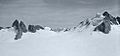
Emperor Peak (left) with Taku Towers centered
-
Taku Towers with Emperor Peak (right)


