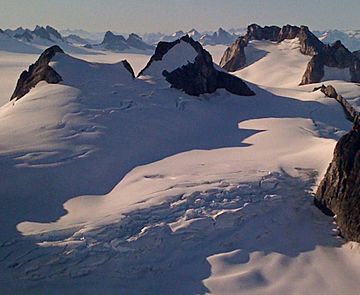
Princess Peak facts for kids
Quick facts for kids Princess Peak |
|
|---|---|

Princess Peak centered, from southeast
(Emperor Peak in upper right) |
|
| Highest point | |
| Elevation | 6,585 ft (2,007 m) |
| Prominence | 985 ft (300 m) |
| Isolation | 1.63 mi (2.62 km) |
| Parent peak | Emperor Peak |
| Geography | |
| Location | Tongass National Forest Juneau Borough Alaska, United States |
| Parent range | Coast Mountains Boundary Ranges Juneau Icefield |
| Topo map | USGS Juneau C-2 |
Princess Peak is a tall mountain covered in ice and snow. It stands about 6,585 feet (2,007 meters) high. This peak is located in the Coast Mountains of Alaska, in the United States.
Princess Peak is part of the Taku Range, which is a section of the huge Juneau Icefield. It's about 18 miles (29 km) north of Juneau. It's also very close to Emperor Peak, and it's all part of the Tongass National Forest. The Taku Range is a long ridge that runs north to south, right next to the massive Taku Glacier.
People from the Juneau Icefield Research Project named Princess Peak in 1964. The name became official in 1965, thanks to the U.S. Board on Geographic Names.
What's the Weather Like at Princess Peak?
Princess Peak has a very cold and snowy climate. It gets long, chilly winters with lots of snow. The summers are cool, but not warm.
Weather systems from the Gulf of Alaska hit the Coast Mountains. This forces the air upwards, which causes a lot of rain and snow to fall. Temperatures can drop below -4°F (-20°C). With strong winds, it can feel even colder, below -22°F (-30°C). The best time to visit or climb Princess Peak is usually in July, when the weather is most favorable.
 | Misty Copeland |
 | Raven Wilkinson |
 | Debra Austin |
 | Aesha Ash |


