Encinas de Abajo facts for kids
Quick facts for kids
Encinas de Abajo
|
|
|---|---|

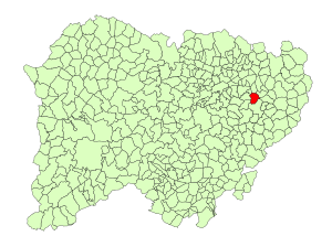
Location in Salamanca
|
|
| Country | Spain |
| Autonomous community | Castile and León |
| Province | Salamanca |
| Comarca | Las Villas |
| Area | |
| • Total | 21 km2 (8 sq mi) |
| Elevation | 796 m (2,612 ft) |
| Population
(2018)
|
|
| • Total | 635 |
| • Density | 30.2/km2 (78.3/sq mi) |
| Time zone | UTC+1 (CET) |
| • Summer (DST) | UTC+2 (CEST) |
| Postal code |
37182
|
Encinas de Abajo is a small village and a municipality (which is like a local government area) in Spain. It is found in the province of Salamanca, which is part of the larger region called Castile and León. This village is about 17 kilometers (around 10.5 miles) away from Salamanca, the main city of the province. In 2018, about 635 people lived there.
Contents
Exploring Encinas de Abajo's Location
Encinas de Abajo covers an area of about 21 square kilometers (around 8 square miles). It sits 796 meters (about 2,611 feet) above sea level. This means it is quite high up! The postal code for the village is 37182.
How Encinas de Abajo is Governed
Like many places, Encinas de Abajo has a local government. This government is led by a mayor. The current mayor is José Luis Haro Sánchez. He belongs to a political group called the People's Party. The mayor and the local council help make decisions for the village.
What Drives the Local Economy
The main way people in Encinas de Abajo make a living is through agriculture. This means farming is very important here. People grow crops and raise animals, which helps support the community.
See also
 In Spanish: Encinas de Abajo para niños
 | Jessica Watkins |
 | Robert Henry Lawrence Jr. |
 | Mae Jemison |
 | Sian Proctor |
 | Guion Bluford |


