Endeavour Strait facts for kids
Quick facts for kids Endeavour Strait |
|
|---|---|

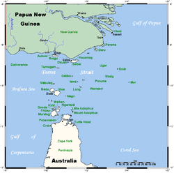
A map of the Torres Strait Islands, with the Endeavour Strait located south of Prince of Wales Island (Muralug) in the Torres Strait
|
|
| Location | Northern Australia |
| Coordinates | 10°47′3″S 142°17′20″E / 10.78417°S 142.28889°E |
| Type | Strait |
| Etymology | The Endeavour |
| Part of | Torres Strait |
| Ocean/sea sources | Arafura Sea |
| Basin countries | Australia |
| Managing agency | Torres Strait Island Region |
| Max. length | 48 km (30 mi) |
| Max. width | 10 km (6.2 mi) |
| Average depth | 15 m (49 ft) |
The Endeavour Strait is a narrow stretch of water in Northern Australia. It separates the Australian mainland (specifically the Cape York Peninsula) from Prince of Wales Island. This strait is part of the larger Torres Strait and is located in the far north of Queensland. It was named in 1770 by the famous explorer James Cook, who sailed through it on his ship, HMS Endeavour. He used this passage to reach the Indian Ocean during his important voyage.
Contents
Exploring Endeavour Strait
The Endeavour Strait is about 48 kilometers (30 miles) long. Its width changes from about 3 to 10 kilometers (2 to 6 miles). On average, the water is about 13 to 15 meters (7 to 8 fathoms) deep. The bottom of the strait is sandy and covered with a layer of coral.
This strait is generally safe for ships to travel through. There are no major hidden dangers or bad areas on the seabed. However, for very large ships, there can be a problem at the western end. This is where the strait connects with the Arafura Sea. Here, the water is much shallower, only about 5.5 meters (3 fathoms) deep.
A Barrier for Early Explorers
The shallow western part of Endeavour Strait was a big challenge for early explorers. For example, Dutch explorers tried to find a way through this area. If they had managed to pass through the strait, they might have discovered eastern Australia much earlier. This could have happened about 150 years before the British explorer James Cook arrived in 1770. The Dutch had already mapped most of Australia's west coast in the early 1600s. This was after Willem Janszoon first saw the Cape York Peninsula in 1606.
The Wreck of the America
The shallow western end of Endeavour Strait also caused a shipwreck. In November 1844, a small ship called the America sank there. Everyone on board was thought to have drowned. However, a 13-year-old Scottish girl named Barbara Thompson survived. She was rescued by the Torres Strait Islanders. These were the Kaurareg people living on Prince of Wales Island. Barbara lived with them for five years.
Modern Use of the Strait
Today, only a few small ships travel through the Endeavour Strait. Its western side is often used as a safe place for these ships to anchor. Because the strait is quite shallow, especially at its western end, it can be dangerous for larger vessels. People have suggested making the strait deeper. However, there are no plans to do this right now.
See also
 In Spanish: Estrecho del Endeavour para niños
 | Bayard Rustin |
 | Jeannette Carter |
 | Jeremiah A. Brown |


