
Entre Ríos Province facts for kids
Quick facts for kids
Entre Ríos
|
|||
|---|---|---|---|

Clockwise from top: El Palmar National Park, Paraná, Carnival in Gualeguaychú, Paraná Delta with Rosario City in the background.
|
|||
|
|||
.svg)
Location of Entre Ríos within Argentina
|
|||
| Country | Argentina | ||
| Capital | Paraná | ||
| Departments | 17 | ||
| Municipalities and board of governors | 266 | ||
| Area | |||
| • Total | 78.781 km2 (30.418 sq mi) | ||
| Population
(2010)
|
|||
| • Total | 1.236.300 (Ranked 7th) | ||
| • Density | 15.7/km2 (41/sq mi) | ||
| Demonym(s) | entrerriano | ||
| Time zone | UTC−3 (ART) | ||
| ISO 3166 code | AR-E | ||


Entre Ríos is a province located in the northeastern part of Argentina. Its capital city is Paraná. This important city sits right on the Paraná River, across from the city of Santa Fe.
The name "Entre Ríos" means "between rivers" in Spanish. This is because the province is surrounded by two major rivers: the Paraná River to the west and the Uruguay River to the east. This unique location makes it a very fertile and interesting place!
Contents
Geography and Nature
Entre Ríos is mostly made up of flat land. You won't find many tall mountains here. Instead, you'll see wide, open plains and gentle hills. The rivers play a huge role in shaping the landscape and supporting the local wildlife.
Rivers and Wetlands
The Paraná River forms the western border of the province. It's one of the longest rivers in South America. The Uruguay River forms the eastern border, separating Entre Ríos from the country of Uruguay. These rivers create many smaller streams, lagoons, and wetlands. These areas are perfect homes for many different plants and animals.
National Parks
Entre Ríos is home to two amazing national parks that protect its natural beauty.
- El Palmar National Park: This park is famous for its large groups of native palm trees. These tall, slender trees create a unique landscape. The park also protects many types of birds, capybaras, and other animals. It's a great place to explore nature.
- Predelta National Park: Located near the city of Diamante, this park protects a part of the Paraná River delta. It's a watery wonderland with islands, swamps, and forests. Many types of fish, birds, and even alligators live here.
Economy and Agriculture
The main way people in Entre Ríos make money is through agriculture. The rich soil and good climate help grow many different crops.
Farm Products
Farmers in Entre Ríos produce a lot of food for Argentina and other countries.
- Grains: Important crops include rice, soybeans, wheat, and maize (corn).
- Fruits: The province is also known for its delicious citrus fruits, like oranges and mandarins.
- Poultry: Entre Ríos is a major producer of chickens and eggs. Many farms raise chickens for meat and eggs, which are sent all over the country.
Other Industries
Besides farming, tourism is growing in Entre Ríos. People visit for the national parks, hot springs, and river activities. The Carnival in Gualeguaychú is also a big event. It attracts many visitors each year with its colorful parades and lively music.
Culture and Traditions
The people of Entre Ríos are called entrerrianos. They have a rich culture influenced by their history and the natural environment.
Carnival of Gualeguaychú
The Carnival of Gualeguaychú is one of the most famous carnivals in Argentina. It takes place every summer and features huge parades with amazing costumes, floats, and music. It's a time for celebration and fun, bringing together locals and tourists.
Historical Sites
The province also has important historical sites. One example is the Palacio San José, which was the home of Justo José de Urquiza. He was a very important political leader in Argentina's history and even served as the first President of modern Argentina.
Images for kids
-
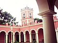
San José Palace, home of the first President of modern Argentina, Justo José de Urquiza
-

Hotel Mayorazgo, Paraná.
-
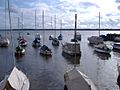
Boats on the Uruguay River, Colón.

.JPG)
_-_Botes_sobre_el_r%C3%ADo_Uruguay.jpg)
See also
 In Spanish: Provincia de Entre Ríos para niños
