Ericsson, Minneapolis facts for kids
Quick facts for kids
Ericsson
|
|
|---|---|
|
Neighborhood
|
|

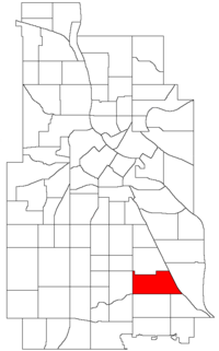
Location of Ericsson within the U.S. city of Minneapolis
|
|
| Country | United States |
| State | Minnesota |
| County | Hennepin |
| City | Minneapolis |
| Community | Nokomis |
| City Council Wards | 11, 12 |
| Area | |
| • Total | 0.91 sq mi (2.4 km2) |
| Population
(2020)
|
|
| • Total | 3,375 |
| • Density | 3,709/sq mi (1,432/km2) |
| Time zone | UTC-6 (CST) |
| • Summer (DST) | UTC-5 (CDT) |
| ZIP code |
55406, 55407
|
| Area code(s) | 612 |
| Historical population | |||
|---|---|---|---|
| Census | Pop. | %± | |
| 1980 | 3,441 | — | |
| 1990 | 3,235 | −6.0% | |
| 2000 | 3,149 | −2.7% | |
| 2010 | 3,192 | 1.4% | |
| 2020 | 3,375 | 5.7% | |
Ericsson is a neighborhood in Minneapolis, Minnesota. It is part of the larger Nokomis community. You can find Ericsson between East 42nd and 43rd Streets to the north, Hiawatha Avenue to the east, Minnehaha Parkway to the south, and Cedar Avenue to the west.
Contents
Exploring Ericsson's Location
Ericsson is home to Lake Hiawatha. This lake is connected to Minnehaha Creek, a well-known waterway in Minneapolis.
Working Together: Standish-Ericsson
Ericsson works together with the Standish neighborhood. They share a neighborhood organization, even though Standish is in a different community called Powderhorn. You might see signs at the neighborhood's edges that say "Standish-Ericsson."
Local Government: City Council Wards
Most of Ericsson is in Ward 12. This area is currently represented by City Council member Aurin Chowdhury. The part of Ericsson west of Lake Hiawatha is in Ward 11. This section is represented by Council Member Emily Koski. These council members help make decisions for the city.
Getting Around: Public Transport
The 46th Street station is located in Ericsson. This station is part of the METRO Blue Line, which is a light rail train system. It helps people travel around the city.
 | Kyle Baker |
 | Joseph Yoakum |
 | Laura Wheeler Waring |
 | Henry Ossawa Tanner |

