Municipal District of Fairview No. 136 facts for kids
Quick facts for kids
Municipal District of Fairview No. 136
|
||
|---|---|---|

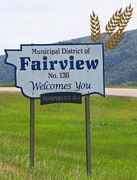
Boundary sign at Dunvegan Bridge
|
||
|
||

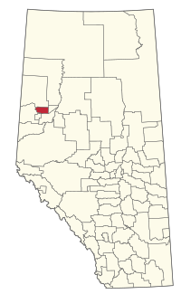
Location within Alberta
|
||
| Country | Canada | |
| Province | Alberta | |
| Region | Northern Alberta | |
| Planning region | Upper Peace | |
| Established | 1913 | |
| Incorporated | 1914 | |
| Area
(2021)
|
||
| • Land | 1,373.66 km2 (530.37 sq mi) | |
| Population
(2021)
|
||
| • Total | 1,580 | |
| • Density | 1.2/km2 (3/sq mi) | |
| Time zone | UTC−7 (MST) | |
| • Summer (DST) | UTC−6 (MDT) | |
The Municipal District of Fairview No. 136 is a special type of local government area in northwestern Alberta, Canada. Think of it like a large rural area that has its own council to manage things. It's located in an area called Census Division 19.
This district stretches along a major road known as Highway 2.
Contents
Exploring the Area
Towns and Hamlets
|
The Municipal District of Fairview No. 136 surrounds one main town: Inside the district, you'll also find smaller communities called hamlets. These are like small villages. The hamlets here include: |
There are also several other small places known as localities within the district. These are even smaller settlements or areas. Some of them are:
|
How Many People Live Here?
Population Changes Over Time
|
||||||||||||||||||||||||||||||||||||||||||||||||||||||||||||||||||||||||
Every few years, Statistics Canada counts how many people live in different areas. This is called a census.
In the 2021 Census, 1,580 people lived in the MD of Fairview No. 136. These people lived in 613 homes. This was a small decrease from 1,604 people in 2016.
The district covers a land area of about 1,373.66 square kilometers. This means there were about 1.2 people living in each square kilometer in 2021. This is called population density.
In the 2016 Census, there were 1,604 people living here. They lived in 620 homes. This was a slight drop from 1,673 people in 2011. The land area was a bit larger then, at 1,387.58 square kilometers.


