
Escholzmatt-Marbach facts for kids
Quick facts for kids
Escholzmatt-Marbach
|
||
|---|---|---|

Escholzmatt village
|
||
|
||

Escholzmatt-Marbach
Location in Switzerland

Escholzmatt-Marbach
Location in Canton of Lucerne
|
||
| Country | Switzerland | |
| Canton | Lucerne | |
| District | Entlebuch | |
| Area | ||
| • Total | 106.4 km2 (41.1 sq mi) | |
| Elevation | 852 m (2,795 ft) | |
| Population
(Dec 2020 )
|
||
| • Total | 4,349 | |
| • Density | 40.874/km2 (105.86/sq mi) | |
| Postal code |
6182
|
|
| Surrounded by | Flühli, Romoos, Schüpfheim, Trub (BE) | |


Escholzmatt-Marbach is a town, also called a municipality, in Switzerland. It is located in the canton of Lucerne. This area is part of the Entlebuch district. On January 1, 2013, the two smaller towns of Escholzmatt and Marbach joined together. They formed the new municipality of Escholzmatt-Marbach.
Contents
History of Escholzmatt-Marbach
The town of Escholzmatt was first written about in history in 1160. Back then, it was called Askolvismatte. Later, in 1240, it was known as Askoltispach and Asholtismate. By 1275, its name changed to Aeschelsmat. Marbach was first mentioned in records in 1306. Its name was Marpach at that time.
Geography of Escholzmatt-Marbach
The total area of Escholzmatt-Marbach is about 106.37 square kilometers (41.07 square miles). This area combines the land from the two original towns.
Escholzmatt's Landscape
The former town of Escholzmatt covered about 61.3 square kilometers (23.7 square miles). Half of this land, 50%, is used for farming. Forests cover a large part, about 44.1% of the land. About 3.1% of the area has buildings or roads. The remaining 2.7% is natural land like rivers or mountains.
Escholzmatt is located on a watershed. This means it's on a high point where water flows in different directions. Water here flows into either the Grosse Emme or Kleine Emme rivers. The lowest point in Escholzmatt is 753 meters (2,470 feet) above sea level. The highest point is 2,090 meters (6,860 feet) high. This high point is on the Schrattenfluh mountain, near Hengst. The area includes the main village of Escholzmatt. It also has smaller villages, called hamlets, like Lehn, Feldmoos, Wiggen, and Dürrenbach.

Marbach's Landscape
The former town of Marbach had an area of about 45.1 square kilometers (17.4 square miles). About 45.3% of its land is used for farming. Forests cover even more of Marbach, about 47.4%. Only a small part, 2.6%, is built up with buildings or roads. The rest, 4.7%, is natural land. Marbach is located in the southwest part of the Lucerne Canton.
Population of Escholzmatt-Marbach
As of December 2011, the total population of Escholzmatt-Marbach was 4,355 people.
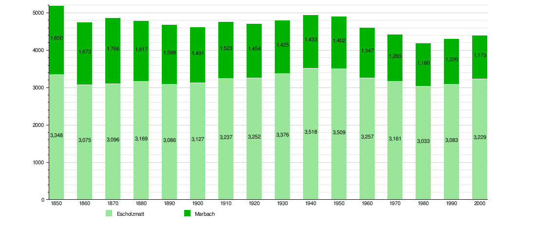
Historical Population Trends
The chart below shows how the population of Escholzmatt and Marbach changed over many years. You can see how many people lived in each town at different times.
Weather in Escholzmatt-Marbach

The weather in Escholzmatt-Marbach can be quite wet.
Escholzmatt's Weather
Escholzmatt has about 153 days of rain each year. On average, it gets 1,424 millimeters (56.1 inches) of precipitation (rain, snow, or hail). June is the wettest month. During June, Escholzmatt gets about 172 millimeters (6.8 inches) of precipitation. It rains for about 15.1 days in June. May has the most rainy days, with an average of 15.5 days. However, it gets less rain than June, about 150 millimeters (5.9 inches). February is the driest month. It only gets about 85 millimeters (3.3 inches) of precipitation. It still rains for about 15.1 days in February.
Marbach's Weather
Marbach experiences about 162.3 days of rain each year. It receives more precipitation than Escholzmatt, with an average of 1,760 millimeters (69 inches). June is also the wettest month in Marbach. It gets about 218 millimeters (8.6 inches) of precipitation. It rains for about 16.4 days in June. May has the most days of precipitation, with an average of 16.9 days. It gets about 179 millimeters (7.0 inches) of precipitation in May. February is the driest month for Marbach. It receives about 112 millimeters (4.4 inches) of precipitation. It rains for about 16.4 days in February.
