Estral Beach, Michigan facts for kids
Quick facts for kids
Estral Beach, Michigan
|
|
|---|---|
|
Village
|
|

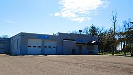
Fire department and village hall
|
|

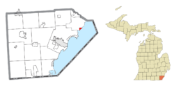
Location within Monroe County and the state of Michigan
|
|
| Country | United States |
| State | Michigan |
| County | Monroe |
| Township | Berlin |
| Incorporated | 1925 |
| Government | |
| • Type | Village council |
| Area | |
| • Total | 0.45 sq mi (1.17 km2) |
| • Land | 0.44 sq mi (1.14 km2) |
| • Water | 0.01 sq mi (0.03 km2) |
| Elevation | 571 ft (174 m) |
| Population
(2020)
|
|
| • Total | 403 |
| • Density | 915.91/sq mi (353.24/km2) |
| Time zone | UTC-5 (Eastern (EST)) |
| • Summer (DST) | UTC-4 (EDT) |
| ZIP Code |
48166 (Newport)
|
| Area code(s) | 734 |
| FIPS code | 26-26460 |
| GNIS feature ID | 0625652 |
Estral Beach is a small village in Monroe County, Michigan. In 2020, about 403 people lived there. The village is part of Berlin Charter Township.
Contents
Village History
Estral Beach became an official village in 1925. Its name comes from a Spanish word meaning "star."
Exploring Estral Beach Geography
Where is Estral Beach Located?
The village is in the northeastern part of Monroe County. It sits right on the northwest shore of Lake Erie. It is also at the mouth of Swan Creek.
Estral Beach is about 8 miles (13 km) south of where the Detroit River meets Lake Erie. It is also about 13 miles (21 km) northeast of Monroe, which is the main city of the county. Rockwood is about 7 miles (11 km) north of the village.
Size and Surroundings
The U.S. Census Bureau says Estral Beach covers about 0.45 square miles (1.17 km2) of land and water. Most of this area, about 0.44 square miles (1.14 km2), is land. Only a small part, about 1.12%, is water.
Nearby, you can find some interesting places. Pointe Mouillee State Game Area is about 1 mile (1.6 km) northeast. This is a great spot for nature lovers. The Enrico Fermi Nuclear Generating Station is about 2 miles (3 km) to the southwest. Also, a part of the Detroit River International Wildlife Refuge is within the northern area of the village.
Estral Beach does not have its own post office. Residents use the 48166 ZIP Code from Newport, which is about 5 miles (8 km) northwest.
Learning and Education
Students in Estral Beach attend schools in the Jefferson Schools district.
Population Over Time
| Historical population | |||
|---|---|---|---|
| Census | Pop. | %± | |
| 1940 | 78 | — | |
| 1950 | 188 | 141.0% | |
| 1960 | 254 | 35.1% | |
| 1970 | 419 | 65.0% | |
| 1980 | 463 | 10.5% | |
| 1990 | 430 | −7.1% | |
| 2000 | 486 | 13.0% | |
| 2010 | 418 | −14.0% | |
| 2020 | 403 | −3.6% | |
| U.S. Decennial Census | |||
The village's population has changed over the years. In 1940, only 78 people lived there. The population grew to 418 people by 2010. By 2020, it was 403 people.
Who Lives in Estral Beach?
In 2010, there were 418 people living in Estral Beach. Most residents, about 99.3%, were White. About 0.7% were Native American. About 1.0% of the population was Hispanic or Latino.
The average age in the village was 45 years old. About 19.9% of the people were under 18. About 13.6% were 65 years old or older. There were slightly more males (53.3%) than females (46.7%).
See also
 In Spanish: Estral Beach para niños


