Ettersburg, California facts for kids
Quick facts for kids
Ettersburg, California
|
|
|---|---|
|
Locale
|
|
 |
|

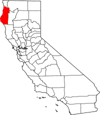
Location in Humboldt County, California and the state of California
|
|
| Country | |
| State | |
| County | Humboldt County |
| Elevation | 669 ft (204 m) |
| Population
(2010)
|
|
| • Total | 10 |
| Time zone | UTC-8 (Pacific (PST)) |
| • Summer (DST) | UTC-7 (PDT) |
| ZIP Code |
95542
|
| Area code(s) | 707 |
| GNIS feature IDs | 1659640; 2611448 |
Ettersburg is a small place in Humboldt County, California. It's also sometimes called Etter. This area is about 12.5 miles (20 km) west-northwest of Phillipsville. It sits at an elevation of about 676 feet (206 m) above sea level.
Contents
History of Ettersburg
Ettersburg had a post office for many years. It was open from 1902 to 1906, and then again from 1915 to 1965. The town is named after its founder, a plant expert named Albert Etter.
Albert Etter and His Plant Experiments
Albert Etter was a very talented plant breeder. His mother, Wilhelmina Etter, was also good at growing plants. Albert started showing his talent for creating new plant types when he was just a kid. By the age of twelve, he was already working with apples, peaches, dahlias, and strawberries.
After finishing school, Albert looked for a good spot to continue his plant-breeding experiments. On a fishing trip to the Mattole River Valley, he found the perfect piece of land. In 1894, he claimed this land, which was located above Bear Creek. This area is along the Pacific coast in the King Range. It has wet winters and hot summers. Albert later said that choosing this location was a big reason for his success. The place where Albert built his ranch was first called Etter, and then later Ettersburg.
Albert ran the ranch with three of his brothers: George, Fred, and August. Four more of his siblings also lived nearby. While Albert focused on breeding new plants, his brothers handled other types of farming and raising animals. Their ranch, called Etter Brothers, eventually grew to be 800 acres big.
Even though the Etter Brothers farm and the Ettersburg Experimental Place became famous around the world among plant breeders, they never became rich from their work. One reason was that they were very far from major roads and train routes. Another reason was that new plant types weren't protected by patents until 1930. This meant others could use Albert's new plants without paying him.
Geography of Ettersburg
Ettersburg is located about 12.5 miles (20 km) west-northwest of Phillipsville. It is about 676 feet (206 m) above sea level.
Nearby Areas
Some cities close to Ettersburg include:
- Shelter Cove, about 8.4 miles south-southwest
- Redway, about 9.3 miles east
- Garberville, about 11 miles east/southeast
- Benbow, about 12.2 miles east-southeast
- Weott, about 13.3 miles north-northeast
- Redcrest, about 18.3 miles north
- Alderpoint, about 20.6 miles east
The area around Ettersburg drains into a space of about 70.9 sq mi (184 km2).
Location and Landscape
Ettersburg is part of the Lost Coast region. This area includes the Pacific Ocean coast and several rivers. Ettersburg is about 241 mi (388 km) northwest of Sacramento and 300 mi (480 km) north of San Francisco. The closest big city is Eureka, which is the main city and county seat of Humboldt County.
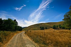
The town is only about 15 mi (24 km) away from the coast. The land gets a little higher as you go north, south, and especially to the east. Beyond the town, you'll find hills and mountains of the rugged coast range. These mountains quickly rise to over 3,200 ft (980 m) in height.
Climate in Ettersburg
Ettersburg has mild to warm summers that are mostly dry. There are not many days where the average monthly temperature goes above 70 °F (21 °C). According to the Köppen Climate Classification system, Ettersburg has a warm-summer Mediterranean climate. This is sometimes called "Csc" on climate maps.
Winters are cool with a lot of rain. Summers are warm and dry, but there is still some rain during these months. Snow in Ettersburg is very rare. It only happens about every 20 to 30 years in the winter.
Temperature and Rainfall
- In January, the average high temperature is 54.0 °F (12.2 °C), and the average low is 41.0 °F (5.0 °C).
- In August, the average high temperature is 62.0 °F (16.7 °C), and the average low is 53.0 °F (11.7 °C).
- The highest temperature ever recorded was 86 °F (30 °C).
- The lowest temperature ever recorded was 21 °F (−6 °C).
- On average, Ettersburg gets about 37.9 inches (960 mm) of rain each year.
- There are about 120 days with measurable rain. This is typical for a Mediterranean climate.
Ettersburg's climate is similar to places like parts of Balmaceda, Chile, high areas in Corsica, Haleakala Summit in Hawaii, and the Cascades or Sierra-Nevada mountain ranges.
| Climate data for Ettersburg, California | |||||||||||||
|---|---|---|---|---|---|---|---|---|---|---|---|---|---|
| Month | Jan | Feb | Mar | Apr | May | Jun | Jul | Aug | Sep | Oct | Nov | Dec | Year |
| Record high °F (°C) | 78.0 (25.6) |
80.0 (26.7) |
76.0 (24.4) |
80.0 (26.7) |
82.0 (27.8) |
85.0 (29.4) |
76.0 (24.4) |
82.0 (27.8) |
86.0 (30.0) |
84.0 (28.9) |
78.0 (25.6) |
77.0 (25.0) |
86.0 (30.0) |
| Mean daily maximum °F (°C) | 54.0 (12.2) |
55.0 (12.8) |
55.0 (12.8) |
56.0 (13.3) |
58.0 (14.4) |
60.0 (15.6) |
61.0 (16.1) |
62.0 (16.7) |
62.0 (16.7) |
61.0 (16.1) |
58.0 (14.4) |
55.0 (12.8) |
58.1 (14.5) |
| Daily mean °F (°C) | 48.0 (8.9) |
49.0 (9.4) |
49.0 (9.4) |
50.0 (10.0) |
53.0 (11.7) |
56.0 (13.3) |
57.0 (13.9) |
58.0 (14.4) |
57.0 (13.9) |
55.0 (12.8) |
52.0 (11.1) |
49.0 (9.4) |
52.8 (11.5) |
| Mean daily minimum °F (°C) | 41.0 (5.0) |
43.0 (6.1) |
43.0 (6.1) |
45.0 (7.2) |
48.0 (8.9) |
51.0 (10.6) |
52.0 (11.1) |
53.0 (11.7) |
51.0 (10.6) |
49.0 (9.4) |
45.0 (7.2) |
42.0 (5.6) |
46.9 (8.3) |
| Record low °F (°C) | 26.0 (−3.3) |
27.0 (−2.8) |
30.0 (−1.1) |
34.0 (1.1) |
36.0 (2.2) |
41.0 (5.0) |
46.0 (7.8) |
46.0 (7.8) |
41.0 (5.0) |
32.0 (0.0) |
30.0 (−1.1) |
21.0 (−6.1) |
21.0 (−6.1) |
| Average precipitation inches (mm) | 6.2 (160) |
5.0 (130) |
5.2 (130) |
2.8 (71) |
1.8 (46) |
0.6 (15) |
0.2 (5.1) |
0.3 (7.6) |
0.8 (20) |
2.9 (74) |
5.8 (150) |
6.3 (160) |
37.9 (968.7) |
| Average precipitation days | 15 | 14 | 16 | 12 | 8 | 6 | 2 | 3 | 5 | 9 | 14 | 16 | 120 |
| Mean monthly sunshine hours | 156.2 | 152.4 | 200.8 | 270.7 | 322.3 | 339.4 | 367.2 | 365.6 | 312.2 | 206.1 | 177.8 | 151.9 | 3,022.6 |
| Mean daily sunshine hours | 5.0 | 5.4 | 6.5 | 9.0 | 10.4 | 11.3 | 11.9 | 11.9 | 10.4 | 6.7 | 5.9 | 4.9 | 8.3 |
| Average ultraviolet index | 3 | 2 | 3 | 4 | 4 | 5 | 5 | 5 | 5 | 4 | 3 | 3 | 4 |
| Source 1: SUN, UV INDEX under worldweatheronline | |||||||||||||
| Source 2: EXTREMES, humidity, dew point under myforecast.co and
Source 3: EXTREMES, humidity, dew point under myforecast.co |
|||||||||||||
Education in Ettersburg
Ettersburg used to have an elementary school from 1980 to 2012. It served students in three grades. Now, students in the area attend school in nearby places like Shelter Cove, Whitehorn, or Garberville.


