Eucalyptus Island facts for kids

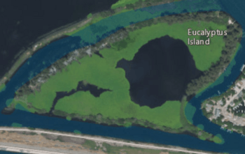
USGS aerial imagery of Eucalyptus Island, with Widdows Island to its northwest and Kings Island to its southeast.
|
|
| Geography | |
|---|---|
| Location | Northern California |
| Coordinates | 37°51′35″N 121°34′15″W / 37.85972°N 121.57083°W |
| Adjacent bodies of water | Sacramento–San Joaquin River Delta |
| Highest elevation | 3 ft (0.9 m) |
| Administration | |
|
United States
|
|
| State | |
| County | Contra Costa |

Eucalyptus Island is a small piece of land surrounded by water, located in the Sacramento–San Joaquin River Delta in Northern California. It's part of Contra Costa County, which is a region in the state of California.
This island's exact spot on a map is at coordinates 37°51′35″N 121°34′15″W / 37.85972°N 121.57083°W. In 1981, the United States Geological Survey (a science agency) measured its height above sea level. They found that Eucalyptus Island is only about 3 ft (0.91 m) tall, which is quite low!
Contents
What is the Sacramento–San Joaquin River Delta?
The Sacramento–San Joaquin River Delta is a very important area in California. It's where two big rivers, the Sacramento and the San Joaquin, meet before flowing into the Pacific Ocean. This area is like a giant network of waterways, channels, and islands.
Why is the Delta important?
The Delta is special for many reasons. It provides drinking water for millions of Californians. It also helps farmers grow crops by supplying water for irrigation. Many different kinds of plants and animals live there, making it an important natural habitat.
Where is Contra Costa County?
Eucalyptus Island is located within Contra Costa County. This county is in the eastern part of the San Francisco Bay Area in California. It's known for its mix of cities, suburbs, and natural areas.
Geography of the County
Contra Costa County has a varied landscape. It includes parts of the Delta, hills, and even some mountains. The county is home to many communities and is an important part of the greater Bay Area region.
 | James B. Knighten |
 | Azellia White |
 | Willa Brown |


