Kings Island (California) facts for kids

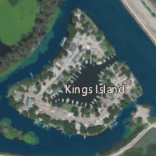
USGS aerial imagery of the island, with Eucalyptus Island to the northwest, Victoria Island to the northeast, and the bridge to the Clifton Court levee to the south.
|
|
| Geography | |
|---|---|
| Location | Northern California |
| Coordinates | 37°51′29″N 121°34′08″W / 37.857982°N 121.568839°W |
| Adjacent bodies of water | Sacramento-San Joaquin River Delta |
| Area | 8.6 acres (3.5 ha) |
| Administration | |
|
United States
|
|
| State | California |
| County | San Joaquin |

Kings Island (which used to be called Bra's Island) is a small piece of land. It is located in the Old River, which is part of the large Sacramento-San Joaquin River Delta in San Joaquin County, California. The island is about 15 kilometers (or 9 miles) southwest of the city of Stockton.
This island is quite tiny, measuring only about 3.5 hectares (which is about 8.6 acres). It is the smallest among a group of delta islands. These include Eucalyptus Island, Widdows Island, Victoria Island, and Coney Island. Kings Island is right next to the Clifton Court Forebay.
Exploring Kings Island
Kings Island sits about 3 feet (or 1 meter) above sea level. The water around it is held back by a system of walls called levees. Because of these levees, the island stays dry and safe.
You can only reach Kings Island in two ways. One way is by using a single road that connects from the Clifton Court levee. The other way to get there is by boat.
 | William L. Dawson |
 | W. E. B. Du Bois |
 | Harry Belafonte |


