Ewing, Virginia facts for kids
Quick facts for kids
Ewing, Virginia
|
|
|---|---|

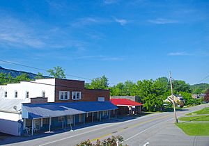
Buildings along Ewing's Dr. Thomas Walker Road in 2017
|
|

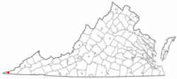
Location of Ewing, Virginia
|
|
| Country | United States |
| State | Virginia |
| County | Lee |
| Area | |
| • Total | 3.76 sq mi (9.75 km2) |
| • Land | 3.76 sq mi (9.75 km2) |
| • Water | 0.004 sq mi (0.01 km2) |
| Elevation | 1,407 ft (429 m) |
| Population
(2010)
|
|
| • Total | 439 |
| • Density | 117/sq mi (45.0/km2) |
| Time zone | UTC−5 (Eastern (EST)) |
| • Summer (DST) | UTC−4 (EDT) |
| ZIP code |
24248
|
| Area code(s) | 276 |
| FIPS code | 51-26384 |
| GNIS feature ID | 1466374 |
Ewing is a small community in Lee County, Virginia. It is known as an unincorporated community, meaning it doesn't have its own local government like a city or town. It's also a census-designated place (CDP), which is an area the U.S. Census Bureau defines for gathering population data. In 2010, about 439 people lived there.
Ewing is one of the westernmost places in Virginia. It's very close to the Cumberland Gap, which is a famous mountain pass. This area is also near the borders of both Kentucky and Tennessee. The Ewing post office first opened in 1891. Today, Ewing is home to Thomas Walker High School and a special animal research center for Lincoln Memorial University.
Where is Ewing Located?
Ewing is found in the western part of Lee County. It sits about 2 miles (3.2 km) south of the Kentucky border. This border follows the top of Cumberland Mountain. Ewing is also less than 3 miles (4.8 km) north of the Tennessee border.
U.S. Route 58 runs right through the middle of Ewing. This road goes east about 20 miles (32 km) to Jonesville. Jonesville is the main town and county seat for Lee County. If you go west on Route 58, it's about 14 miles (22.5 km) to Cumberland Gap, Tennessee. Ewing is quite far from Virginia's capital, Richmond, about 404 miles (650 km) to the southwest.
Ewing's Land and Water
The United States Census Bureau says that the Ewing CDP covers a total area of about 3.7 square miles (9.7 square kilometers). Almost all of this area is land. Only a tiny part, about 0.06%, is water. Ewing is located in the valley of Indian Creek. This creek flows west-southwest and eventually joins the Powell River in Tennessee.
Who Lives in Ewing?
The population of Ewing has changed a bit over the years:
- In 2000, there were 436 people.
- In 2010, the population was 439.
- In 2020, it was 381.
In 2000, there were 183 households in Ewing. About 32% of these households had children under 18 living with them. Most households (54.6%) were married couples. About 28% of all households were made up of people living alone. Around 13% of these were people aged 65 or older living by themselves.
The average household in Ewing had about 2.38 people. The average family size was about 2.91 people.
The people in Ewing were spread out by age:
- 25.5% were under 18 years old.
- 6.9% were between 18 and 24.
- 24.8% were between 25 and 44.
- 26.4% were between 45 and 64.
- 16.5% were 65 years or older.
The average age of people in Ewing was 40 years old. For every 100 females, there were about 87.9 males.
See also
 In Spanish: Ewing (Virginia) para niños
 | Claudette Colvin |
 | Myrlie Evers-Williams |
 | Alberta Odell Jones |

