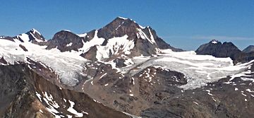
Eyebrow Peak facts for kids
Quick facts for kids Eyebrow Peak |
|
|---|---|

Eyebrow Peak, south aspect
|
|
| Highest point | |
| Elevation | 3,362 m (11,030 ft) |
| Prominence | 901 m (2,956 ft) |
| Parent peak | Commander Mountain (3371 m) |
| Geography | |
| Location | British Columbia, Canada |
| Parent range | Purcell Mountains |
| Topo map | NTS 82K/7 |
| Climbing | |
| First ascent | 1914 Brown, Harnden, Nettleton, Parson |
| Easiest route | class 3 |
Eyebrow Peak is a very tall mountain in the Purcell Mountains of British Columbia, Canada. It stands at 3,362 meters (about 11,030 feet) high. This mountain has large glaciers, which are like huge, slow-moving rivers of ice. It is the ninth-highest peak in the Purcell Mountains.
Eyebrow Peak is located about 28 kilometers (17 miles) south of The Bugaboos. It is also 44 kilometers (27 miles) west of Invermere. The mountain is 6 kilometers (4 miles) north of Mount Monica. Its closest taller neighbor is Commander Mountain, which is 11.4 kilometers (7 miles) to the southeast.
The first time people successfully climbed to the top of Eyebrow Peak was in 1914. A team of four climbers, Edward Warren Harnden, D. Brown, L. Nettleton, and E. Parson, reached the summit. They climbed up the mountain's west slopes.
The mountain got its unique name, Eyebrow Peak, in 1910. A person named Arthur Oliver Wheeler saw two large rock marks near the top. These marks, along with the snow around them, looked like giant eyebrows. However, Wheeler later realized he had actually seen Mount Farnham because of bad weather. So, the name Eyebrow was then given to the mountain we know today. The name was officially accepted on June 9, 1960.
Climate and Weather
Eyebrow Peak is in a subarctic climate zone. This means it has very cold and snowy winters. The summers are usually mild. Temperatures can drop below −20 °C (−4 °F). With wind chill, it can feel even colder, sometimes below −30 °C (−22 °F).
The snow and ice that melt from Eyebrow Peak and its nearby glaciers flow into Horsethief Creek. This creek then flows into the Columbia River.
Climbing the Mountain
There are several known ways to climb Eyebrow Peak. These are called "climbing routes."
- West Slopes: This was the route used for the first climb in 1914. It is rated as class 3 in difficulty.
- Southwest Face: This route was first climbed in 1928.
- West Face: This route was also first climbed in 1928.
- South Ridge: This route was first climbed in 1928 as well.
See also
 In Spanish: Pico Eyebrow para niños
 | Anna J. Cooper |
 | Mary McLeod Bethune |
 | Lillie Mae Bradford |


