Fairhaven Ditch facts for kids
Quick facts for kids |
|
|
Fairhaven Ditch
|
|

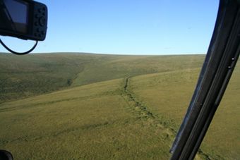
Aerial view of part of the ditch (Park Service photo)
|
|
| Location | Address restricted |
|---|---|
| Nearest city | Deering, Alaska |
| Area | 4,969 acres (2,011 ha) |
| Built | 1907 |
| Built by | Fairhaven Water Company |
| Architect | C.L. Morris |
| NRHP reference No. | 87001579 |
| Added to NRHP | September 23, 1987 |
The Fairhaven Ditch is a historic canal in northwestern Alaska. It's found on the Seward Peninsula inside the Bering Land Bridge National Preserve. This amazing ditch is about 38-mile (61 km) long. It was dug between 1906 and 1907 without any heavy machinery. Imagine digging such a long ditch in a very tough environment!
Miners built the ditch to help them find gold. They used a method called placer mining, which means looking for gold in riverbeds or streams. The ditch moved water from Imuruk Lake, the biggest freshwater lake on the peninsula. This water then flowed to the mining areas north of the lake. The Fairhaven Ditch was one of many canals built there, and it was one of the longest. It was dug through permanently frozen ground, called permafrost, and even through a volcanic area. The ditch was about 11 feet (3.4 m) wide at the bottom. Old cabins where workers lived and watched the water flow are still there today. The Fairhaven Ditch became a protected historic site in 1987.
Contents
Why Was the Fairhaven Ditch Built?
Gold Mining in Alaska
In the early 1900s, many people went to Alaska hoping to find gold. This was during the time of the Alaska Gold Rush. Miners needed a lot of water to separate gold from dirt and gravel. They would use powerful jets of water to wash away the soil, leaving the heavier gold behind.
The Fairhaven Ditch was built to bring water to these gold mining operations. It was a huge project that showed how determined the miners were. They needed a steady supply of water, especially since the mining areas were far from natural water sources.
How Was the Ditch Constructed?
Digging Through Tough Ground
Building the Fairhaven Ditch was incredibly difficult. Workers had to dig through frozen ground, also known as permafrost. This ground is as hard as rock! They also dug through areas with volcanic rock and regular dirt. All of this was done by hand, with picks and shovels, because there were no big machines like excavators back then.
The ditch was designed to be 11 feet wide at the bottom. It had a slight slope, about 4.2 feet per mile, to keep the water flowing. When the water was first let into the ditch, the frozen ground at the bottom started to thaw. This caused parts of the ditch to settle and widen, sometimes to 15 or 20 feet. Workers had to constantly maintain the ditch, especially in areas where the ground was mostly ice and muck.
Building in Sections
The Fairhaven Ditch was built in three main parts. The top part, about 17 miles long, started at Imuruk Lake. A 500-foot-long dam was built at the lake to store water. This section of the ditch carried water around Wade Creek.
The middle section was much shorter, about half a mile long. It helped move water from Wade Creek to Pinnell River. There was a gap of about 6.5 miles between the upper and lower parts of the ditch.
The lower section of the ditch was about 19 miles long. It started at Pinnell River and went along the valley to a point near Logan Gulch. In total, the ditch was about 36.5 miles long.
When Was the Ditch Completed?
A Long Construction Project
Construction on the Fairhaven Ditch began in early 1906. By October of that year, the upper part and more than half of the lower part were finished. But work had to stop for the winter because of the harsh weather.
The entire ditch was finally completed in July 1907. Water flowed through it for the first time in September of the same year. This massive project took a lot of hard work and dedication from the miners and builders. It stands as a testament to the challenges and ingenuity of the gold rush era.
 | Precious Adams |
 | Lauren Anderson |
 | Janet Collins |

