
False Pass, Alaska facts for kids
Quick facts for kids
False Pass
Isanax̂
|
|
|---|---|

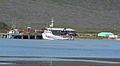
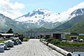
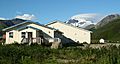
False Pass looking north
|
|
| Nickname(s): | |

False Pass, Alaska
Location in Alaska
|
|
| Country | United States |
| State | Alaska |
| Borough | Aleutians East |
| Incorporated | October 19, 1990 |
| Area | |
| • Total | 65.55 sq mi (169.76 km2) |
| • Land | 25.07 sq mi (64.93 km2) |
| • Water | 40.48 sq mi (104.83 km2) |
| Elevation | 30 ft (9 m) |
| Population
(2020)approximately 35 permanent residents
|
|
| • Total | 397 |
| • Density | 15.84/sq mi (6.11/km2) |
| Time zone | UTC-9 (Alaska (AKST)) |
| • Summer (DST) | UTC-8 (AKDT) |
| ZIP codes |
99583
|
| Area code | 907 |
| FIPS code | 02-24660 |
| GNIS feature ID | 1418574 |
| Website | City Website |

False Pass is a small city in Alaska, located on Unimak Island. Its local name in the Aleut language is Isanax̂. While many people work there during fishing season, only about 35 people live there all year. In 2020, the census counted 397 people, but most of these were seasonal workers.
Contents
History of False Pass
False Pass gets its name from Isanotski Strait, a narrow waterway where the city is located. Early American sailors called it "False Pass" because they thought their large ships couldn't get through its northern end.
In 1919, a factory that canned salmon was built on the Unimak Island side of the strait. This factory helped the modern town grow. A U.S. post office named False Pass opened in 1921, making the community official.
Today, fishing is still a very important part of life and the economy in False Pass. People fish for salmon, cod, halibut, and crab.
Geography of False Pass

False Pass is located near the eastern end of Unimak Island, which is part of the Aleutian Islands chain. The city is at coordinates 54°49′40″N 163°23′57″W.
A small part of the city is also on the western tip of the Alaska Peninsula, across the Isanotski Strait. This part is about 600 meters away at its closest point and has almost no people living there. The city's boundaries also include two old, abandoned villages called Morzhovoi and Ikatan.
According to the U.S. Census Bureau, False Pass covers a total area of about 177 square kilometers (68.3 square miles). Most of this area, about 107 square kilometers (41.4 square miles), is water. The land area is about 69.7 square kilometers (26.9 square miles).
Transportation in False Pass
The only ways to travel to and from False Pass are by boat or by airplane. Airplanes use the False Pass Airport.
Population and Demographics
| Historical population | |||
|---|---|---|---|
| Census | Pop. | %± | |
| 1930 | 59 | — | |
| 1940 | 88 | 49.2% | |
| 1950 | 42 | −52.3% | |
| 1960 | 41 | −2.4% | |
| 1970 | 62 | 51.2% | |
| 1980 | 70 | 12.9% | |
| 1990 | 68 | −2.9% | |
| 2000 | 64 | −5.9% | |
| 2010 | 35 | −45.3% | |
| 2020 | 397 | 1,034.3% | |
| U.S. Decennial Census | |||
False Pass first appeared in the U.S. Census in 1930. Back then, it was listed as "Unimak" and included people from both False Pass and Ikatan. In 1950, it was listed separately as False Pass.
The population numbers can change a lot because many people come to False Pass for seasonal work, especially in the fishing industry.
Education in False Pass
The Aleutians East Borough School District (AEBSD) is in charge of the False Pass School. Around 1978, the school had only one teacher and eight students.
Picture gallery
-
Crab boats loading pots in False Pass, AK.
-
Local salmon seiner, False Pass, AK.
-
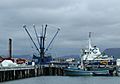
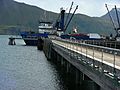
Gillnetters at Peter Pan dock, False Pass, AK.
-
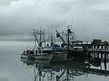
Salmon boats at dock in False Pass, AK.
-
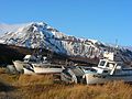
Salmon boats hauled up in False Pass, AK.
-
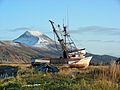
Local salmon seiner "up for the winter".
-
Seattle freighter arrives twice a month at False Pass.
-
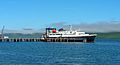
Alaska Ferry Tustamena arrives monthly in False Pass.
-
Peter Pan dock, looking west, False Pass.
-
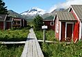
Old cannery board walks, False Pass.
-
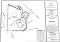
Original plat for cannery, False Pass.
-
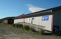
False Pass P.O., library, City Offices.
-
False Pass Medical Clinic.
-
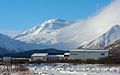
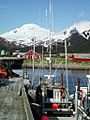
False Pass School and Roundtop volcano.
-
False Pass grocery store & city dock.
-
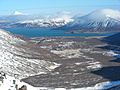
View east down Roundtop Valley, False Pass.
-
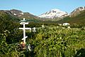
Cemetery in False Pass, Alaska.


See also
 In Spanish: False Pass para niños
