Federation of Bosnia and Herzegovina facts for kids
Quick facts for kids
Federation of Bosnia and Herzegovina
Federacija Bosne i Hercegovine
Федерација Босне и Херцеговине |
|
|---|---|

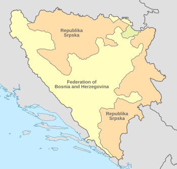
Location of the Federation of Bosnia and
Herzegovina (yellow) within Bosnia and Herzegovina. Brčko District is shown in pale green.a |
|
| Capital and largest city
|
Sarajevo 43°52′N 18°25′E / 43.867°N 18.417°E |
| Official languages |
|
| Ethnic groups
(2013)
|
|
| Government | Federated state |
| Marinko Čavara | |
| Fadil Novalić | |
| Legislature | Parliament |
| House of Peoples | |
| House of Representatives | |
| Formation | |
|
• Washington Agreement
|
18 March 1994 |
|
• Recognized as
part of Bosnia and Herzegovina |
14 December 1995 |
| Area | |
|
• Total
|
26,110.5 km2 (10,081.3 sq mi) |
| Population | |
|
• 2013 census
|
2,219,220 |
|
• Density
|
91/km2 (235.7/sq mi) |
| Currency | Convertible mark (BAM) |
| Time zone | UTC+1 (CET) |
|
• Summer (DST)
|
UTC+2 (CEST) |
| Calling code | +387 |
| ISO 3166 code | BA-BIH |
|
|
The Federation of Bosnia and Herzegovina (often called FB&H or Federation of B&H) is one of two main parts that make up the country of Bosnia and Herzegovina. It is a special kind of state where different groups live together. The Federation of Bosnia and Herzegovina has its own government and is divided into 10 smaller areas called cantons. Each canton also has its own local government.
Contents
Understanding the Federation of Bosnia and Herzegovina
The Federation of Bosnia and Herzegovina is a unique part of Bosnia and Herzegovina. It was created to help different groups of people live and work together after a difficult period. It has its own president, prime minister, and parliament, which are like the leaders and law-making body for this part of the country.
How the Government Works
The Federation of Bosnia and Herzegovina has a system of government that helps manage its affairs.
- The President is like the head of the Federation.
- The Prime Minister leads the government and helps make decisions.
- The Parliament is where laws are discussed and made. It has two parts: the House of Peoples and the House of Representatives. These groups work together to create rules for everyone living in the Federation.
Official Languages Spoken
In the Federation of Bosnia and Herzegovina, three languages are officially recognized:
This means that people can use any of these languages in official settings, like in schools or government offices.
Exploring the Cantons
The Federation of Bosnia and Herzegovina is divided into 10 smaller regions called cantons. Think of them like states or provinces within a larger country. Each canton has its own government that takes care of local matters, like schools and hospitals, for the people living there.
Here are the 10 cantons:
- Bosnian Podrinje
- Canton 10
- Central Bosnia
- Herzegovina-Neretva
- Posavina
- Sarajevo
- Tuzla
- Una-Sana
- West Herzegovina
- Zenica-Doboj
Quick Facts About the Federation
- Capital City: The capital of the Federation of Bosnia and Herzegovina is Sarajevo. It is also the largest city.
- Area: The total area of the Federation is about 26,110.5 square kilometers (10,085 square miles).
- Population: In 2013, about 2,219,220 people lived in the Federation.
- Currency: The money used here is called the Convertible mark (BAM).
- Time Zone: The Federation uses Central European Time (CET), which is UTC+1. During summer, they switch to Central European Summer Time (CEST), which is UTC+2.
See also
 In Spanish: Federación de Bosnia y Herzegovina para niños
 | Janet Taylor Pickett |
 | Synthia Saint James |
 | Howardena Pindell |
 | Faith Ringgold |

