
Ferguson, Kentucky facts for kids
Quick facts for kids
Ferguson, Kentucky
|
|
|---|---|

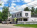
Ferguson City Hall
|
|

Location of Ferguson in Pulaski County, Kentucky.
|
|
| Country | United States |
| State | Kentucky |
| County | Pulaski |
| Area | |
| • Total | 2.01 sq mi (5.21 km2) |
| • Land | 2.01 sq mi (5.21 km2) |
| • Water | 0.00 sq mi (0.01 km2) |
| Elevation | 1,060 ft (320 m) |
| Population
(2020)
|
|
| • Total | 886 |
| • Density | 440.58/sq mi (170.15/km2) |
| Time zone | UTC-5 (Eastern (EST)) |
| • Summer (DST) | UTC-4 (EDT) |
| ZIP code |
42533
|
| Area code(s) | 606 |
| FIPS code | 21-27010 |
| GNIS feature ID | 2403606 |
Ferguson is a small city in Pulaski County, Kentucky, United States. It is a home rule-class city, meaning it has the power to govern itself. Ferguson is located just south of downtown Somerset. In 2020, about 886 people lived there.
Contents
History of Ferguson
Ferguson was first built as a place for workers of the Cincinnati Southern Railroad to live. These workers fixed train engines. The city became official in 1906. It was probably named after Edward A. Ferguson, a lawyer who helped start the railroad.
For a long time, Ferguson used the name Luretha for its mail. This was because another town in Kentucky already had a post office named Ferguson. Luretha was the name of the first postmaster's daughter. In 1950, the other post office closed. Then, the city was finally allowed to use the name Ferguson for its mail.
The railroad shops in Ferguson were made for steam engines. When trains started using diesel engines in the mid-1900s, the shops closed.
Ferguson School History
Ferguson School opened in 1910. It taught students from first grade all the way to twelfth grade. The school served children from the town and nearby rural areas. The high school had about 100 to 150 students.
The high school closed in 1968, and the elementary school closed in 1978. Today, the land where the school once stood is now Ferguson Park. The old school buildings are now used as community center offices and for fun activities. Students from Ferguson now go to Southwestern-Pulaski County High School.
Geography of Ferguson
Ferguson is mainly located along Kentucky Route 1247, also known as Murphy Avenue. It stretches south toward Kentucky Route 914. The city of Somerset surrounds Ferguson on its north, west, and south sides. The Cumberland River (which forms Lake Cumberland) is to the southwest.
According to the United States Census Bureau, Ferguson covers a total area of about 2.01 square miles (5.21 square kilometers). All of this area is land.
Population and People
| Historical population | |||
|---|---|---|---|
| Census | Pop. | %± | |
| 1910 | 404 | — | |
| 1920 | 529 | 30.9% | |
| 1930 | 532 | 0.6% | |
| 1940 | 517 | −2.8% | |
| 1950 | 550 | 6.4% | |
| 1960 | 468 | −14.9% | |
| 1970 | 507 | 8.3% | |
| 1980 | 1,009 | 99.0% | |
| 1990 | 934 | −7.4% | |
| 2000 | 881 | −5.7% | |
| 2010 | 924 | 4.9% | |
| 2020 | 886 | −4.1% | |
| U.S. Decennial Census | |||
In 2000, there were 881 people living in Ferguson. There were 360 households and 249 families. The population density was about 504 people per square mile. Most of the people living in Ferguson were White (97.62%).
About 27.8% of households had children under 18 living with them. Many households (56.4%) were married couples living together. About 26.1% of all households were made up of individuals living alone. About 11.7% of households had someone aged 65 or older living alone. The average household had 2.45 people.
The population was spread out by age. About 22.9% of the people were under 18. About 13.6% were 65 years or older. The average age in the city was 38 years.
Images for kids
-
Ferguson Post Office

See also
 In Spanish: Ferguson (Kentucky) para niños
