
Fishers Gap facts for kids
Quick facts for kids Fishers Gap |
|
|---|---|

View northwest from Fishers Gap Overlook
|
|
| Elevation | 3,064 ft (934 m) |
| Location | Madison / Page counties, Virginia, United States |
| Range | Blue Ridge Mountains |
| Coordinates | 38°32′00″N 078°25′15″W / 38.53333°N 78.42083°W |
Fishers Gap is a special spot in the Blue Ridge Mountains of Virginia. It's a "wind gap," which means it's a low point or pass in a mountain ridge. You can find it right on the border of Madison County and Page County, inside the beautiful Shenandoah National Park.
Two famous paths cross Fishers Gap: the scenic Skyline Drive and the long-distance Appalachian Trail.
Contents
Exploring Fishers Gap's Location
Fishers Gap sits about 2,000 feet (or 610 meters) higher than the land around it. It's like a natural dip in the mountains.
If you look north from the gap, you'll see Hawksbill Mountain. This is the tallest mountain in Shenandoah National Park. Fishers Gap is nearly 1,000 feet (about 305 meters) lower than Hawksbill. To the south, you'll find Big Meadows and Stony Man Mountain. Fishers Gap is about 300 feet (or 91 meters) lower than these areas.
Two small rivers also start near the gap. The Rose River flows down the eastern side, and Little Hawksbill Creek flows down the western side.
The History of Fishers Gap
Fishers Gap has a cool history, named after an early settler and playing a part in important events.
How Fishers Gap Got Its Name
The gap is named after a man named Stephen Fisher. He received a special land grant for 216 acres (about 87 hectares) at the gap on August 4, 1778. This grant officially gave him ownership of the land. Over time, this land was sold several times. Eventually, in 1931, it was bought by the Virginia State Commission on Conservation. Later, the National Park Service took over the land for Shenandoah National Park.
Milam's Pass: An Older Name
Before it was called Fishers Gap, this pass was often known as "Milam's Pass." This name came from Thomas Milam, an early settler who lived near Double Top Mountain between the 1740s and 1760s. He was likely the first person to discover this path across the Blue Ridge Mountains into the Shenandoah Valley. His name stuck to the pass for a long time.
The Gordonsville New Market Turnpike
Fishers Gap didn't appear on maps until after a major road was built. This road was called the Gordonsville New Market Turnpike. A "turnpike" was a toll road, meaning you had to pay to use it. This turnpike was finished in the spring of 1853.
During the American Civil War, this turnpike became very important. In November 1862, Confederate General Thomas "Stonewall" Jackson rode across Fishers Gap on this turnpike. Just two weeks later, he led most of his army along this same road. They were on their way to Fredericksburg, where Jackson played a big role in the Battle of Fredericksburg a month later.
Sadly, the Civil War took a toll on the turnpike. Both armies used the road, which caused a lot of damage. By June 1867, the company that managed the turnpike was "disorganized," and the toll gates were closed.
From Turnpike to Skyline Drive
Today, you won't find the old turnpike. Instead, the beautiful 105-mile-long Skyline Drive was built through Shenandoah National Park between 1933 and 1939. Near mile marker 50, just north of the Big Meadows area, you'll find the Fishers Gap Overlook. It's a great spot to stop and enjoy the view from 3,140 feet (957 meters) up!
Some parts of the old Gordonsville New Market Turnpike still exist. They are now used as fire roads within the park, known as the Rose River and Redgate fire roads.
Images for kids
-
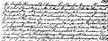
Stephen Fisher's 1778 Northern Neck Land Grant
-
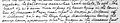
Isaac N. Long's 1894 Madison County Purchase Deed
-
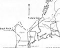
1932 U S Geological Survey of Shenandoah National Park, Madison Tract 141
-
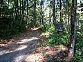
Photo of Rose River Fire Road in Shenandoah National Park


