
Flat Fell facts for kids
Quick facts for kids Flat Fell |
|
|---|---|

Flat Fell from Dent
|
|
| Highest point | |
| Elevation | 272 m (892 ft) |
| Parent peak | Dent |
| Listing | Outlying Wainwright |
| Geography | |

Flat Fell
Location in Lake District
|
|
| OS grid | NY052137 |
Flat Fell is a small but interesting hill found near the edge of the famous Lake District in England. It stands about 272 meters (892 feet) tall. This hill is special because it's mentioned in a famous book called Outlying Fells of Lakeland by Alfred Wainwright. He wrote about many hills in the Lake District, and Flat Fell shares a chapter with a nearby hill called Dent. Wainwright described a path that starts at Wath Brow to explore both hills.
What Flat Fell Looks Like
Flat Fell has a long, stretched-out shape, a bit like a slug. On its eastern side, there's a steep slope called Flatfell Screes. This slope helps form one side of a valley where a small stream, called Nannycatch Beck, flows.
A famous long-distance walking path, the Coast to Coast Walk, follows part of Nannycatch Beck. Unlike its neighbor, Dent, Flat Fell doesn't have many trees. Instead, it's mostly covered in open grassy areas where sheep and horses often graze. The southern and eastern parts of the hill are also covered with plants like bracken and gorse.
How to Climb Flat Fell
Getting to Flat Fell is quite easy because there are two public paths that run alongside it. One path, a bridleway (which means horses can use it too), runs along the southern side of the hill. The other path, a footpath, is on the northern side. This northern path connects to a road called Fell Road near the Kinniside Stone Circle, which is an ancient monument.
Both of these paths meet up at the end of Nannycatch road, on the western side of the hill. While these paths get you close, there aren't any clear, marked trails that lead directly from them to the very top of Flat Fell. You'll need to find your own way to the summit from the main paths.
The Summit and Amazing Views
When you reach the very top of Flat Fell, you'll find a small pile of stones called a cairn. This cairn wasn't there when Alfred Wainwright visited the hill, but it's a helpful marker now.
From the summit, you can enjoy wide-open views across West Cumbria, which is the area around the hill. You can also see other nearby fells (hills) like Dent, Grike, Blakeley Raise, and Lank Rigg. It's a great spot to take in the landscape!
Gallery
-
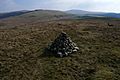
The Summit of Flat Fell, looking East towards Grike, Blakeley Raise and Lank Rigg
-
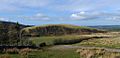
East face of Flat Fell


