Flint River (Alabama) facts for kids
Quick facts for kids Flint River |
|
|---|---|

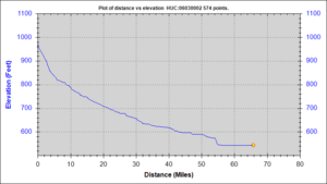
Elevation Profile vs River Length
|
|
| Country | United States |
| States | Alabama and Tennessee |
| Physical characteristics | |
| Main source | Lincoln County, Tennessee 558 ft (170 m) |
| River mouth | Tennessee River |
| Length | 65.7 mi (105.7 km) |
| Basin features | |
| Basin size | 568 sq mi (1,470 km2) |
The Flint River is a river that flows for about 65.7 mi (105.7 km) (65.7 miles). It's like a smaller stream that feeds into a bigger one, which is called a tributary. The Flint River is a tributary of the Tennessee River.
This river starts in Lincoln County, Tennessee. From there, it flows south into Madison County, Alabama. Most of the land that drains water into the Flint River, called its watershed, is in Madison County. This watershed covers about 342 square miles.
The land around the Flint River is mostly used for farming. However, more and more homes are being built there, especially because of the nearby city of Huntsville. Scientists from the U.S. Geological Survey are studying the water quality in the Flint River. They want to make sure the water is clean and healthy.
Contents
River Features and Flow
The Flint River is about 65.7 miles long. It collects water from an area of about 568 sq mi (1,470 km2) (568 square miles). This area is its watershed, where all the rain and smaller streams eventually flow into the river.
Where the River Starts
The Flint River begins in Lincoln County, Tennessee. It then flows south into Alabama. The river's journey ends when it joins the larger Tennessee River.
Land Around the River
The land around the Flint River is mostly farms. But new houses are being built because the city of Huntsville is growing. This growth can sometimes affect the river's environment.
Checking Water Quality
The U.S. Geological Survey has a program to check the water quality in rivers like the Flint River. They do this to understand how healthy the river is. This helps protect the river and the animals that live in it.
River Rocks and Geology
The Flint River starts near the edge of the Cumberland Plateau. This area is like a big, flat-topped mountain. The river flows through plains that were formed as parts of the Appalachian Mountains wore away over time.
What the Rocks Are Made Of
The rocks in this area are mostly sedimentary. This means they are made from layers of sand and other materials that piled up over millions of years. These rocks often contain sandstone.
Special Quartz Stones
Because of the type of rock in the area, you can sometimes find small pieces of a special stone called star blue quartz in the riverbed. This quartz is very strong and doesn't break down easily. So, it survives even as the surrounding rocks wear away.
 | Frances Mary Albrier |
 | Whitney Young |
 | Muhammad Ali |

