
Florence, Colorado facts for kids
Quick facts for kids
Florence, Colorado
|
||
|---|---|---|
| City of Florence | ||

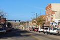
Entering Florence from the east on Colorado State Highway 115.
|
||
|
||

Location of the City of Florence in Fremont County, Colorado.
|
||

Florence, Colorado
Location in the United States
|
||
| Country | ||
| State | ||
| County | Fremont County | |
| Incorporated | September 13, 1887 | |
| Government | ||
| • Type | Statutory City | |
| Area | ||
| • Total | 4.282 sq mi (11.091 km2) | |
| • Land | 4.276 sq mi (11.076 km2) | |
| • Water | 0.006 sq mi (0.015 km2) | |
| Elevation | 5,200 ft (1,600 m) | |
| Population
(2020)
|
||
| • Total | 3,822 | |
| • Density | 894/sq mi (345/km2) | |
| • Metro | 48,939 | |
| • CSA | 217,101 | |
| • Front Range | 5,055,344 | |
| Time zone | UTC−07:00 (MST) | |
| • Summer (DST) | UTC−06:00 (MDT) | |
| ZIP codes |
81226 & 81290
|
|
| Area code(s) | 719 | |
| FIPS code | 08-27040 | |
| GNIS feature ID | 2410510 | |

Florence is a city in Fremont County, Colorado, in the United States. It is known as a "statutory city," which means it follows specific state laws for how it is run. In 2020, about 3,822 people lived there. Florence is part of a larger area that includes Cañon City and the Front Range Urban Corridor.
Contents
History of Florence
Florence started as an important center for transportation. It had three railroads, including a small depot. These trains carried coal from nearby towns like Rockvale and Coal Creek.
In 1862, oil was discovered in Florence. This made Florence the first major oil center west of the Mississippi River. The town grew quickly in the early 1880s because of this oil boom.
The city was named after Florence, who was the daughter of an early settler named James McCandless. Florence officially became a city in 1887. The historic downtown area of Florence was added to the National Register of Historic Places in 2017.
Geography and Location
Florence is located in the eastern part of Fremont County. It sits on the south side of the Arkansas River. To the west, it shares a border with the town of Williamsburg. The town of Coal Creek is about 3 miles (5 km) to the southwest.
Colorado State Highway 115 runs northwest from Florence for about 9 miles (14 km) to Cañon City. It also goes northeast about 6 miles (10 km) to Penrose. Both directions connect with U.S. Route 50. Colorado State Highway 67 goes north about 3.5 miles (5.6 km) to US 50 and south about 11 miles (18 km) to Wetmore. The city of Pueblo is about 33 miles (53 km) east of Florence.
In 2020, Florence covered a total area of about 4.28 square miles (11.091 km²). Only a very small part of this area is water. Florence is located in the dry, high desert lands of southern Colorado.
Population Information
| Historical population | |||
|---|---|---|---|
| Census | Pop. | %± | |
| 1900 | 3,728 | — | |
| 1910 | 2,712 | −27.3% | |
| 1920 | 2,629 | −3.1% | |
| 1930 | 2,475 | −5.9% | |
| 1940 | 2,632 | 6.3% | |
| 1950 | 2,773 | 5.4% | |
| 1960 | 2,821 | 1.7% | |
| 1970 | 2,846 | 0.9% | |
| 1980 | 2,987 | 5.0% | |
| 1990 | 2,990 | 0.1% | |
| 2000 | 3,653 | 22.2% | |
| 2010 | 3,881 | 6.2% | |
| 2020 | 3,822 | −1.5% | |
| U.S. Decennial Census | |||
According to the census in 2000, Florence had 3,653 people living there. There were 1,488 households and 973 families. The population density was about 898 people per square mile (347 people per km²).
About 27.5% of the population was under 18 years old. About 16.5% of the population was 65 years or older. The average age in the city was 36 years old.
Education in Florence
The Fremont RE-2 School District is in charge of the public schools in Florence. These schools include Penrose Elementary School, Florence Elementary School, and Florence Junior/Senior High School.
Notable Person
- Thyra Thomson, who served as the Secretary of State for Wyoming.
Images for kids
-
Downtown Florence, in 2017

See also
 In Spanish: Florence (Colorado) para niños
