Foard County, Texas facts for kids
Quick facts for kids
Foard County
|
|
|---|---|

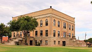
The Foard County Courthouse in Crowell, Texas
|
|

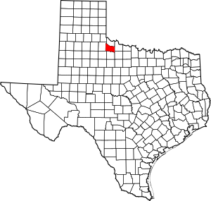
Location within the U.S. state of Texas
|
|
 Texas's location within the U.S. |
|
| Country | |
| State | |
| Founded | 1891 |
| Named for | Robert Levi Foard |
| Seat | Crowell |
| Largest city | Crowell |
| Area | |
| • Total | 708 sq mi (1,830 km2) |
| • Land | 704 sq mi (1,824 km2) |
| • Water | 3.3 sq mi (9 km2) 0.5% |
| Population
(2020)
|
|
| • Total | 1,095 |
| • Estimate
(2023)
|
1,079 |
| • Density | 1.532/sq mi (0.5914/km2) |
| Time zone | UTC−6 (Central) |
| • Summer (DST) | UTC−5 (CDT) |
| Congressional district | 13th |
Foard County is a small county located in the northern part of Texas, a state in the United States. In 2020, about 1,095 people lived there.
The main town and county seat (the place where the county government is) is Crowell. It's the only town in the county that is officially organized. Foard County is named after Robert Levi Foard. He was a lawyer who served as a major during the American Civil War.
For a long time, Foard County was a "dry county." This meant that selling alcoholic drinks was not allowed. However, in May 2006, people in the county voted to allow the legal sale of these beverages.
Contents
Exploring Foard County's Land
According to the United States Census Bureau, Foard County covers a total area of about 708 square miles. Most of this area, about 704 square miles, is land. A small part, about 3.3 square miles, is covered by water.
Main Roads in Foard County
These are the most important roads that go through Foard County:
 U.S. Highway 70
 State Highway 6
Neighboring Counties
Foard County shares its borders with several other counties:
- To the north: Hardeman County
- To the east: Wilbarger County
- To the southeast: Baylor County
- To the south: Knox County
- To the southwest: King County
- To the west: Cottle County
People of Foard County
The number of people living in Foard County has changed over the years. Here's a quick look at the population from past censuses:
| Historical population | |||
|---|---|---|---|
| Census | Pop. | %± | |
| 1900 | 1,568 | — | |
| 1910 | 5,726 | 265.2% | |
| 1920 | 4,747 | −17.1% | |
| 1930 | 6,315 | 33.0% | |
| 1940 | 5,237 | −17.1% | |
| 1950 | 4,216 | −19.5% | |
| 1960 | 3,125 | −25.9% | |
| 1970 | 2,211 | −29.2% | |
| 1980 | 2,158 | −2.4% | |
| 1990 | 1,794 | −16.9% | |
| 2000 | 1,622 | −9.6% | |
| 2010 | 1,336 | −17.6% | |
| 2020 | 1,095 | −18.0% | |
| 2023 (est.) | 1,079 | −19.2% | |
| U.S. Decennial Census 1850–2010 2010–2020 |
|||
In 2020, the United States Census counted 1,095 people living in Foard County. Most residents were White (not Hispanic or Latino). About 18% of the population was Hispanic or Latino. A small number of people were Black or African American, Asian, or of mixed races.
Places to Visit
Foard County and its nearby areas offer a few interesting spots:
- Copper Breaks State Park: This park is located close to the Pease River. It's about 8 miles north of Crowell, just off State Highway 6. While it's a popular spot for people from Foard County, the park itself is actually in neighboring Hardeman County.
- Comanche Springs Astronomy Campus: This campus is about 10 miles west of Crowell, off U.S. Highway 70. It's part of the 3 Rivers Ranch and is managed by the Texas Tech University System. It's a great place for stargazing!
Towns and Communities
Learning in Foard County
Students in Foard County attend schools in these districts:
- Crowell Independent School District
- Vernon Independent School District
For higher education, the county is served by Vernon College.
See also
 In Spanish: Condado de Foard para niños

