
Fort Gaddis facts for kids
|
Thomas Gaddis Homestead
|
|
.jpg)
Thomas Gaddis House (Exterior)
|
|

Location in Pennsylvania

Location in the United States
|
|
| Location | South of Uniontown off U.S. Route 119, South Union Township, Pennsylvania |
|---|---|
| Area | 2 acres (0.81 ha) |
| Built | 1798 |
| NRHP reference No. | 74001782 |
Quick facts for kids Significant dates |
|
| Added to NRHP | April 26, 1974 |
Fort Gaddis is a very old building in Fayette County, Pennsylvania. It is the oldest known building in the county. It is also the second oldest log cabin in Western Pennsylvania.
You can find Fort Gaddis about 300 yards (270 m) east of old U.S. Route 119. It is near the Route 857 intersection in South Union Township, Fayette County, Pennsylvania. This is east of Hopwood and south of Uniontown.
Colonel Thomas Gaddis built Fort Gaddis around 1769-1774. He was in charge of defending the area. His home likely served as a meeting place for the community. It also offered shelter during emergencies. This is why it became known as "Fort Gaddis." This name probably came about in the 1800s. The building is a 1 1/2-story log structure. It has one room and measures 26 feet (7.9 m) long and 20 feet (6.1 m) wide.
Contents
Fort Gaddis: A Historic Pennsylvania Building
A Place for Community and Protest
During the Whiskey Rebellion, an important event happened here. The Whiskey Rebellion was a protest by farmers against a tax on whiskey. A Liberty Pole was put up at Fort Gaddis. This happened during a rally to support the protest.
Choosing this spot for a political gathering shows its importance. It was a key place for the community to express its views. In the early 1900s, all newer parts of the building were removed. This was done to show respect for the original section. This part was built around the time of the American Revolution and the Whiskey Rebellion. This shows how important Fort Gaddis has been as a community symbol for a long time.
On the Old Trails
Fort Gaddis was built near the Catawba Trail. This was a very important route running north and south. It stretched from New York to Tennessee. The trail passed through Uniontown, Pennsylvania and Morgantown, West Virginia.
In the 1800s, people in the area called this trail the Morgantown Road. Today, it is known as Old U.S. Route 119. About 2 miles (3.2 km) north on this road is Uniontown. Uniontown is the main town in Fayette County, Pennsylvania. It was settled in the late 1760s and founded in July 1776.
Other Names for Fort Gaddis
Fort Gaddis is known by a few different names. Depending on what you are reading, you might see it called the "Thomas Gaddis Homestead." It can also be called the "Thomas Gaddis House" or "Gaddis' Fort."
Fort Gaddis was added to the National Register of Historic Places in 1974. It was listed under the name "Thomas Gaddis Homestead."
Gallery
-
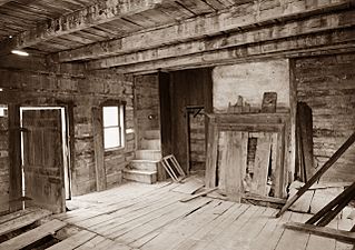
Thomas Gaddis House (Interior)
-
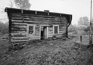
Photo taken during ca1989 restoration
-
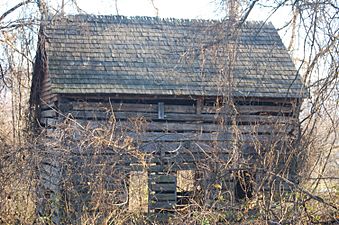
Photo taken in 2012
-
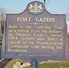
Road Marker
.jpg)


