
Hopwood, Pennsylvania facts for kids
Quick facts for kids
Hopwood, Pennsylvania
|
|
|---|---|

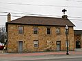
The Hopwood-Miller Tavern
|
|
| Etymology: John Hopwood | |

Location of Hopwood in Fayette County
|
|
| Country | United States |
| State | Pennsylvania |
| County | Fayette |
| Townships | North Union, South Union |
| Area | |
| • Total | 1.89 sq mi (4.88 km2) |
| • Land | 1.89 sq mi (4.88 km2) |
| • Water | 0.00 sq mi (0.00 km2) |
| Population
(2020)
|
|
| • Total | 2,062 |
| • Density | 1,093.32/sq mi (422.21/km2) |
| Time zone | UTC-4 (EST) |
| • Summer (DST) | UTC-5 (EDT) |
| ZIP code |
15445
|
| Area code(s) | 724 |
| FIPS code | 42-35728 |
Hopwood is a small community in Fayette County, Pennsylvania, United States. It is known as a census-designated place (CDP), which is a special area defined for gathering census information. In 2020, about 2,062 people lived there. Hopwood is located in two areas called townships: North Union and South Union. The village was named after John Hopwood, a Baptist preacher. For a short time, it was even called Monroe.
Contents
Geography and Location
Hopwood is in the middle of Fayette County. It is next to East Uniontown to the north. A main road, U.S. Route 40 Business (also known as National Pike), goes through the center of Hopwood. This road also marks the border between North and South Union townships.
The center of Uniontown is about 2 miles (3.2 km) to the northwest. You can get there by taking National Pike. U.S. Route 40 is a larger four-lane road that goes around the south side of Uniontown. It connects with National Pike at the south end of Hopwood. From US 40, it's about 60 miles (97 km) southeast to Cumberland, Maryland, and 45 miles (72 km) northwest to Washington.
Hopwood covers a total area of about 1.89 square miles (4.89 square kilometers), and all of it is land. The community is located at the western base of Chestnut Ridge. This ridge is the westernmost part of the Allegheny Mountains in this area.
History of Hopwood
Hopwood has a rich history, including events that led to major wars.
Early Conflicts
The Battle of Jumonville Glen happened near Hopwood on May 28, 1754. This small fight helped start the French and Indian War.
Racing History
From 1916 to the mid-1920s, Hopwood was home to the famous Uniontown Speedway. This was a popular place for car races. Important national championship races, like the Universal Trophy and Autumn Classic, were held there in 1921 and 1922. Before car racing was banned in the area, hill-climb races were held up the nearby Summit Mountain in 1914 and 1915.
Historic Buildings
Hopwood has many old stone buildings from the 1800s along the National Pike. Several of these buildings are listed on the National Register of Historic Places.
One famous building is the Hopwood-Miller Tavern. In 1816, President Monroe stayed there when it was known as the Moses Hopwood House. Other important people and Presidents, like John Quincy Adams, William Henry Harrison, James Polk, and James Buchanan, also stayed at this inn.
Other notable buildings in the area include the Barnes Estate and the Summit Inn. There was also a Soldiers Orphan's School, which cared for children after the Civil War. This building is now part of the Jumonville Camp & Retreat Center.
Population Information
| Historical population | |||
|---|---|---|---|
| Census | Pop. | %± | |
| 2020 | 2,062 | — | |
| U.S. Decennial Census | |||
In 2000, there were 2,006 people living in Hopwood. There were 893 households and 584 families. About 23.7% of households had children under 18. Many households (52.6%) were married couples. The average household had 2.25 people.
The population was spread out by age. About 19.5% were under 18, and 21.1% were 65 or older. The average age was 44 years old. For every 100 females, there were about 95 males.
Notable People
- William DeFord (1807–1898), who was a member of the Ohio House of Representatives.
See also
 In Spanish: Hopwood (Pensilvania) para niños
Images for kids
-
Morris Hair Tavern

