
Fort Sumner (Maryland) facts for kids
Quick facts for kids Fort Sumner |
|
|---|---|
| Part of the Civil War Defenses of Washington | |
| Montgomery County, Maryland | |

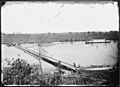
View of the Potomac River from Fort Sumner
|
|

Fort Sumner
|
|
| Coordinates | 38°57′19″N 77°07′26″W / 38.9554°N 77.1240°W |
| Type | Earthwork fort |
| Site information | |
| Controlled by | Union Army |
| Condition | Residential area |
| Site history | |
| Built | 1861 |
| Built by | U.S. Army Corps of Engineers |
| In use | 1861–1865 |
| Materials | Earth, timber |
| Demolished | 1953 |
| Battles/wars | American Civil War |
Fort Sumner was a special fort built during the American Civil War. The Union Army constructed it in 1861. It was located in the Brookmont area of Bethesda, Maryland. This spot was just northwest of Washington, D.C..
Contents
Building Fort Sumner: A Key Civil War Defense


Fort Sumner was an "earthwork fort." This means it was mainly built using earth and timber. It was part of a bigger plan to protect Washington, D.C. The fort was an expansion of three smaller forts: Fort Alexander, Fort Ripley, and Fort Franklin.
Why Fort Sumner Was Built
The main reason for building these forts was to protect the Washington Aqueduct. This aqueduct was a new system that brought fresh water to the city. The forts also guarded the nearby Potomac River shoreline. This river was very important for transportation and defense.
Who Fort Sumner Was Named After
Fort Sumner was named in honor of Major General Edwin Vose Sumner. He was a brave leader in the Union Army. Sadly, he passed away in 1863 from a fever. The fort was named after him to remember his service.
What Fort Sumner Looked Like
The fort was built on high ground. This gave it an excellent view over the Potomac River. It was equipped with 30 artillery pieces, which are large cannons. These cannons helped defend the area from enemy attacks. The site also included two smaller defense points. These were called Battery Bailey and Battery Benson. They watched over Little Falls Branch, a small stream nearby.
What Remains of Fort Sumner Today
Fort Sumner was taken down in 1953. Today, you won't see the full fort. However, a few parts of Battery Bailey can still be seen. You can find them in Westmoreland Hills Park. They are visible from the Capital Crescent Trail, a popular walking path.
Later Uses of the Fort Site
During World War II, a part of the fort's land was used by the Army Map Service (AMS). This group made maps for the military. The site was even renamed Fort Sumner for a while. Later, the AMS became part of other mapping agencies. These agencies used the site until the early 2010s.
Fort Sumner's Legacy in the Community
Today, a neighborhood stands where Fort Sumner once was. There is a special plaque about the fort. You can find it at Sangamore Road and West Path Way. Some parts of the residential area are named "Fort Sumner Hills" and "Sumner Village." These names help remember the historic fort.
Images for kids
-
Pontoon bridge from Fort Sumner

