Fortymile River facts for kids
Quick facts for kids Fortymile River |
|
|---|---|

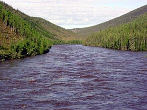
Fortymile River from Taylor Highway
|
|
|
Location of the mouth of the Fortymile River in Yukon
|
|
| Native name | Hän language Ch'èdà Dëk |
| Countries |
|
| States/Territories | |
| Physical characteristics | |
| Main source | confluence of the river's North Fork and South Fork northwest of Chicken, Alaska, United States 1,424 m (4,672 ft) 64°14′34″N 141°45′15″W / 64.24278°N 141.75417°W |
| River mouth | Yukon River Forty Mile, Yukon, Canada 950 ft (290 m) 64°25′35″N 140°32′00″W / 64.42639°N 140.53333°W |
| Length | 60 mi (97 km) |
| Basin features | |
| Basin size | 6,600 sq mi (17,000 km2) |
| Type: | Wild, Scenic, Recreational |
| Designated: | December 2, 1980 |
The Fortymile River is a 60-mile (97 km) long river. It flows into the Yukon River. This river is found in both Alaska in the United States and the Yukon territory in Canada.
The Fortymile River starts where its North and South Forks meet in Southeast Fairbanks Census Area. From there, it flows mostly northeast into Canada. It joins the larger Yukon River about 32 miles (51 km) southeast of Eagle, Alaska.
Contents
Discovering the Fortymile River's Past
The Fortymile River got its name from gold miners. They found gold here in 1886. The river's mouth was about 40 miles from Fort Reliance. This was an old trading post on the Yukon River.
How Gold Shaped the River's History
Miners dug up a lot of gold from the Fortymile area. They found over half a million ounces! After gold was discovered, two traders, Jack McQuesten and Arthur Harper, built a trading post at the river's mouth.
Mining and Restoration Efforts
Between 1968 and 1978, a company called Cassiar Mining dug for asbestos near Clinton Creek. This creek flows into the Fortymile River in Yukon. They removed about a million metric tons of asbestos.
After the company left the site, they went out of business. The governments of Yukon and Canada then worked to clean up the area. They removed or buried mining waste and helped restore the land.
Protecting the Fortymile River
In 1980, parts of the Fortymile River in Alaska were added to the National Wild and Scenic Rivers System. This system helps protect special rivers in the United States. About 392 miles (631 km) of streams in the Fortymile area are protected.
What Does "Wild and Scenic" Mean?
The protected parts of the river are divided into three types:
- Wild: These parts are very natural and untouched.
- Scenic: These parts have beautiful views and are mostly undeveloped.
- Recreational: These parts are easy to reach and good for fun activities.
Visiting the Fortymile Wild and Scenic River
The Bureau of Land Management looks after the Fortymile Wild and Scenic River. You can get to it from the Taylor Highway in Alaska. There's also an unpaved road from the Top of the World Highway in Yukon.
Many fun outdoor activities are possible here. You can go floating on the river, camping, and sightseeing. It's a great place to explore nature.
Boating Adventures on the Fortymile River
The Fortymile River and its branches offer many boating options. It's best for experienced paddlers using rafts, kayaks, or canoes. Some parts of the river have rapids, so you might need to carry your boat around them.
Understanding River Difficulty Levels
The river segments range from Class I (easy) to Class V (extremely difficult) on the International Scale of River Difficulty. Besides rapids, watch out for tree branches hanging over or under the water. It's also easy to get lost without a map and compass.
The Kink: A Unique Engineering Feat
One interesting spot is called the Kink. It's an artificial channel on the North Fork of the river. Miners blasted this channel through a ridge in 1904. This was done to expose 3 miles (5 km) of the original riverbed so they could look for gold on dry land.
The Kink is now listed on the National Register of Historic Places. It's recognized as an important engineering project from the early 1900s.
 | Tommie Smith |
 | Simone Manuel |
 | Shani Davis |
 | Simone Biles |
 | Alice Coachman |


