Franklin Bay facts for kids

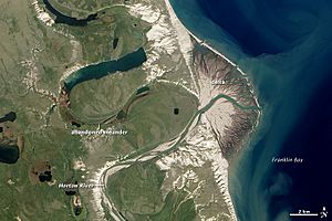
Franklin Bay is a large body of water in the Northwest Territories, Canada. It's like a big arm reaching out from the Amundsen Gulf. This gulf is part of the southeastern Beaufort Sea. Think of it as a large bay connected to an even bigger sea.
This bay is about 48 kilometers (30 miles) long. At its widest point, it's about 40 kilometers (25 miles) across. To the east of Franklin Bay, you'll find the Parry Peninsula. A part of the bay in the south is called Langton Bay.
The Horton River flows into Franklin Bay. Sometimes, especially in early winter, there can be strong winds called gales here.
Franklin Bay got its name from a famous Arctic explorer, Sir John Franklin. He was honored by John Richardson in 1826.
A Look Back: History of Franklin Bay
People have explored and mapped Franklin Bay over the years.
Early Maps and Explorers
In 1875, a French missionary named Émile Petitot made some maps. He was also a cartographer (someone who makes maps) and a geographer. Petitot heard stories about the area. Based on these stories, he mistakenly drew the Hornaday River flowing into Franklin Bay. It actually flows into a different bay called Darnley Bay.
Arctic Expeditions
Langton Bay, which is part of Franklin Bay, was an important base. From 1909 to 1912, two Arctic explorers used it for their journeys. These explorers were Vilhjalmur Stefansson and Rudolph Anderson. They spent three years exploring the Arctic from this spot.
69°40′N 125°30′W / 69.667°N 125.500°W
 | Dorothy Vaughan |
 | Charles Henry Turner |
 | Hildrus Poindexter |
 | Henry Cecil McBay |

