Franklin Island (Antarctica) facts for kids
 |
|
|
Location in Antarctica
|
|
| Geography | |
|---|---|
| Location | Antarctica |
| Coordinates | 76°5′S 168°19′E / 76.083°S 168.317°E |
| Length | 13 km (8.1 mi) |
| Administration | |
| Administered under the Antarctic Treaty System | |
| Demographics | |
| Population | Uninhabited |
Franklin Island is a remote island in the icy Ross Sea, close to Antarctica. It is about 13 kilometers (7 miles) long. This island was found on January 27, 1841, by the explorer James Clark Ross. He named it after Sir John Franklin, a well-known Arctic explorer. Sir John Franklin had hosted Ross's expedition in Hobart, Tasmania, in 1840.
Contents
Island Location and Features
Franklin Island is located about 130 kilometers (80 miles) east of Cape Hickey in Victoria Land. Even though it is only about 80 kilometers (50 miles) north of Beaufort Island, it is usually not considered part of the Ross Archipelago.
What is Franklin Island Made Of?
Franklin Island is what remains of an old shield volcano. A shield volcano is a type of volcano that is wide and flat, like a warrior's shield. This volcano formed about 4.8 million years ago. The main opening, or vent, of the volcano is now underwater off the island's east coast. Over time, the island has been worn down by weather and ice.
Special Places on the Island
The very southern tip of Franklin Island is called Bernacchi Head. Its coordinates are 76°8′S 168°20′E. Close by, you can find the Franklin Shoals. These are shallow areas of water located at 76°0′S 169°0′E.
Wildlife on Franklin Island
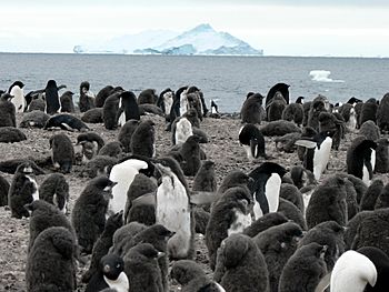
Franklin Island is home to a large breeding colony of Adélie penguins. These penguins come to the island to lay their eggs and raise their chicks. It is an important place for these birds in the Antarctic region.
 | Bayard Rustin |
 | Jeannette Carter |
 | Jeremiah A. Brown |


