Freedom Plains, New York facts for kids
Quick facts for kids
Freedom Plains, New York
|
|
|---|---|

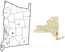
Location of Freedom Plains, New York
|
|
| Country | United States |
| State | New York |
| County | Dutchess |
| Town | LaGrange |
| Area | |
| • Total | 1.33 sq mi (3.46 km2) |
| • Land | 1.29 sq mi (3.34 km2) |
| • Water | 0.04 sq mi (0.11 km2) |
| Elevation | 315 ft (96 m) |
| Population
(2020)
|
|
| • Total | 438 |
| • Density | 339.27/sq mi (131.04/km2) |
| Time zone | UTC-5 (Eastern (EST)) |
| • Summer (DST) | UTC-4 (EDT) |
| ZIP code |
12540
|
| Area code(s) | 845 |
| FIPS code | 36-27452 |
| GNIS feature ID | 0950660 |
Freedom Plains is a small community in Dutchess County, New York, United States. It is known as a hamlet, which is a small settlement, and also a census-designated place (CDP). A CDP is an area that the U.S. Census Bureau defines for gathering population data. In 2020, about 438 people lived in Freedom Plains.
Contents
Geography of Freedom Plains
Freedom Plains is located right in the middle of the town of LaGrange. This area is in the south-central part of Dutchess County.
Travel and Roads
New York State Route 55 is a main road that goes through Freedom Plains.
- If you go west on Route 55, you will reach Poughkeepsie, which is about 7 miles away. Poughkeepsie is the main city for the county.
- If you go southeast on Route 55, you will find Pawling, about 13 miles away.
The Taconic State Parkway is a major highway that runs along the eastern side of Freedom Plains.
- Going north on the parkway, you can travel about 57 miles to Interstate 90.
- Going south, it's about 70 miles to reach New York City.
Land and Water Area
Freedom Plains is next to James Baird State Park on its northern side. This park offers a place for outdoor activities.
The total area of Freedom Plains is about 3.45 square kilometers (or 1.33 square miles). Most of this area is land, about 3.34 square kilometers (1.29 square miles). A small part, about 0.11 square kilometers (0.04 square miles), is water.
Population Information
| Historical population | |||
|---|---|---|---|
| Census | Pop. | %± | |
| 2020 | 438 | — | |
| U.S. Decennial Census | |||
The population of Freedom Plains was counted during the 2020 United States Census. At that time, there were 438 people living in the area. This number helps us understand how many people call Freedom Plains home.
Education in Freedom Plains
Students in Freedom Plains attend schools within the Arlington Central School District. This school district serves the community and includes Arlington High School, where older students go for their high school education.
See also
 In Spanish: Freedom Plains para niños
 | Isaac Myers |
 | D. Hamilton Jackson |
 | A. Philip Randolph |

