French Gulch, California facts for kids
Quick facts for kids
French Gulch
|
|
|---|---|
 |
|

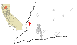
Location in Shasta County and the state of California
|
|
| Country | |
| State | |
| County | Shasta |
| Area | |
| • Total | 12.369 sq mi (32.035 km2) |
| • Land | 12.332 sq mi (31.940 km2) |
| • Water | 0.037 sq mi (0.095 km2) 0.30% |
| Elevation | 1,355 ft (425 m) |
| Population
(2020)
|
|
| • Total | 373 |
| • Density | 30.16/sq mi (11.644/km2) |
| Time zone | UTC-8 (Pacific (PST)) |
| • Summer (DST) | UTC-7 (PDT) |
| ZIP code |
96033
|
| Area code(s) | 530 |
| FIPS code | 06-26056 |
| GNIS feature ID | 0223907 |
| Reference #: | 166 |
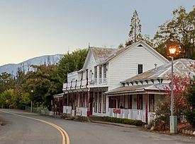
French Gulch is a small community in Shasta County, California, United States. It's called a "census-designated place" (CDP) because it's a recognized area, but it's not officially a city. In 2020, about 373 people lived there. This was a small increase from 346 people in 2010.
Contents
History of French Gulch
How French Gulch Started
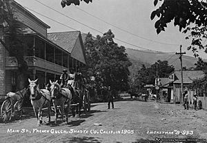
French Gulch began in 1849. It was founded by French miners who came to California looking for gold. The area quickly became one of California's most important gold-producing regions.
The town also became a key supply center. It was the end point of the western branch of the California Trail. This made it a vital stop for travelers and miners. In 1935, French Gulch was recognized as a California Historical Landmark.
Gold Mining in French Gulch
French Gulch was famous for its "hard rock" mining. This means miners dug deep into the earth to find gold veins. The Washington vein system was found in 1852. It was mined off and on until about 1914. It's believed to have produced about 100,000 ounces of gold.
Another important mine was the Niagara Mine. It produced about 50,000 ounces of gold in its early days. As of 2008, some mining has started again at both the Washington and Niagara mines.
Battling Wildfires
French Gulch has faced challenges from large wildfires.
On August 14, 2004, everyone in French Gulch had to leave their homes. A huge forest fire was burning out of control in Shasta County. The fire burned over 13,000 acres. It destroyed 26 homes and many other buildings. Residents were able to return home three days later, on August 17, 2004. More than 1,300 firefighters worked to control the blaze. The cause of this fire was never found.
Another major fire, the Carr Fire, led to another evacuation on July 22, 2018. This fire started because of a car problem. Firefighters worked hard to protect the town. Many historic buildings, including the old hotel, were saved. On August 8, the evacuation order was lifted, and people could go back home.
Geography and Location
French Gulch is located at 40°42′19″N 122°38′7″W / 40.70528°N 122.63528°W. It sits a few miles northwest of Whiskeytown Lake. The community is along Trinity Mountain Road, which goes north from California State Route 299. The center of town is about 3 miles north of Highway 299. It's also about 19 miles by road from downtown Redding.
According to the United States Census Bureau, French Gulch covers about 12.4 square miles. Almost all of this area (99.70%) is land, and a small part (0.30%) is water.
Population and People
French Gulch in 2010
In 2010, the population of French Gulch was 346 people. Most residents, about 85.5%, identified as White. There were also people who identified as African American, Native American, Asian, Pacific Islander, or from two or more races. About 4.9% of the population was Hispanic or Latino.
There were 147 households in French Gulch. About 21.8% of these households had children under 18 living in them. The average household size was 2.35 people. The median age of residents was 49.6 years old. This means half the people were younger than 49.6, and half were older.
Most homes (81.0%) were owned by the people living in them. The rest (19.0%) were rented.
See also
 In Spanish: French Gulch para niños


