Friendship, Oklahoma facts for kids
Quick facts for kids
Friendship, Oklahoma
|
|
|---|---|

Friendship state historical marker
|
|
| Country | United States |
| State | Oklahoma |
| County | Jackson |
| Area | |
| • Total | 0.15 sq mi (0.39 km2) |
| • Land | 0.15 sq mi (0.39 km2) |
| • Water | 0.00 sq mi (0.00 km2) |
| Elevation | 1,394 ft (425 m) |
| Population
(2020)
|
|
| • Total | 23 |
| • Density | 153.33/sq mi (59.20/km2) |
| Time zone | UTC-6 (Central (CST)) |
| • Summer (DST) | UTC-5 (CDT) |
| Area code(s) | 580 |
| FIPS code | 40-27900 |
| GNIS feature ID | 2412660 |
Friendship is a very small town in Jackson County, Oklahoma, in the United States. It's so tiny that in 2020, only 23 people lived there! That's just one person less than in 2010, when 24 people called Friendship home.
Contents
History
Early Days of Friendship
Before Oklahoma became the 46th state, the area where Friendship is located was part of different territories. It was known as Indian Territory, Oklahoma Territory, and even claimed by Texas as Greer County.
Land of Buffalo and Cowboys
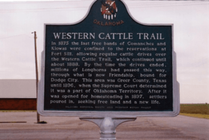
Long ago, southwestern Oklahoma was a huge grassland. Millions of buffalo roamed here! The Comanche and Kiowa people lived in this area. After 1875, the area became safe for cattle drives. From 1876 to 1892, millions of longhorn cattle were moved from Texas to places like Dodge City, Kansas, and Ogallala, Nebraska. This journey happened on the Great Western Cattle Trail, which went right through what is now Friendship.
How Oklahoma Claimed the Land
In the 1880s, large cattle companies from Texas moved into southwestern Oklahoma. Texas claimed this land as Greer County. But in 1890, the Oklahoma Territory was created. A lawsuit was filed to decide who owned the land. In 1896, the U.S. Supreme Court decided that the area belonged to Oklahoma Territory, not Texas. This meant the land was opened for homesteading in 1897. Homesteading allowed people to claim and settle on land.
How Friendship Got Its Name
Over the years, several small communities grew in the Friendship area. These included places like Clabber Flat, Alfalfa, and Navajoe. The Clabber Flat School opened in 1899. It later changed its name to Friendship School because it was connected to the Friendship Baptist Church. The church often met at the school.
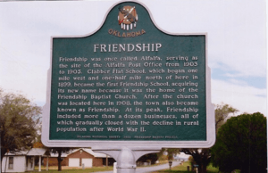
Friendship was first known as "Alfalfa." It even had the Alfalfa Post Office from 1903 to 1905. In 1908, the Friendship Baptist Church was built in Alfalfa. Soon after, the town became known as "Friendship."
Growing and Changing Schools
In 1920, the Friendship and Navajoe School Districts joined together. Parts of other school districts also joined to form a new, larger Friendship Consolidated District. In 1935, Pleasant Point also joined with Friendship. Later, students from the Ozark and Headrick School Districts came to Friendship.
A Busy Town
Friendship was a busy place in the early 1900s. At its busiest, the town had two gas stations, two grocery stores, two cotton gins (places that separate cotton fibers), and two blacksmith shops. It also had a garage, a hardware store, a barber shop, a cafe, a feed mill, and a domino parlor. About twenty homes were in the town. Besides the Friendship Baptist Church, the Midway Methodist Church was built in 1913, just a mile east of town.
Changes After World War II
After World War II, it became easier for people to travel. Residents started going to nearby Altus for shopping and services. Many people also moved from farms to cities. Because of this, businesses in Friendship slowly closed down.
In 1962, the Friendship School burned down. Friendship and Warren schools then joined to form a new school district called Navajo. A new school was built between the two towns in 1963. The Midway Methodist Church also closed in 1982.
Today
Friendship officially became an incorporated town in 1999. Recently, more homes have been built nearby. However, within the town limits, you'll mostly find the Friendship Baptist Church, a community center (which also houses the Friendship Volunteer Fire Department), and a few homes.
Geography
Friendship is located in the northeastern part of Jackson County. It is about 10 miles (16 km) northeast of Altus, which is the main town in the county.
According to the U.S. Census Bureau, Friendship covers an area of 0.39 square kilometers (0.15 sq mi). All of this area is land.
Demographics
| Historical population | |||
|---|---|---|---|
| Census | Pop. | %± | |
| 2010 | 24 | — | |
| 2020 | 23 | −4.2% | |
| U.S. Decennial Census | |||
See also
 In Spanish: Friendship (Oklahoma) para niños


