
Friendship, Wisconsin facts for kids
- There is also the Town of Friendship in Fond du Lac County.
Quick facts for kids
Friendship, Wisconsin
|
|
|---|---|
|
Village
|
|

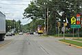
Looking north in downtown Friendship on WIS 13
|
|

Location in Adams County and the state of Wisconsin.
|
|
| Country | United States |
| State | Wisconsin |
| County | Adams |
| Area | |
| • Total | 0.92 sq mi (2.38 km2) |
| • Land | 0.88 sq mi (2.28 km2) |
| • Water | 0.04 sq mi (0.10 km2) |
| Elevation | 955 ft (291 m) |
| Population
(2010)
|
|
| • Total | 725 |
| • Estimate
(2012)
|
686 |
| • Density | 823.9/sq mi (318.1/km2) |
| Time zone | UTC-6 (Central (CST)) |
| • Summer (DST) | UTC-5 (CDT) |
| ZIP code |
53934
|
| Area code(s) | 608 |
| FIPS code | 55-27950 |
| GNIS feature ID | 1565329 |

Friendship is a village in Adams County in the U.S. state of Wisconsin. The population was 725 at the 2010 census.
Contents
Geology
The Friendship Mound sits just to the north of town. It is a castillated mound formed from the last glaciers to cover the area during the Ice Age. Another mound, Roche-A-Cri, is a few miles north of the village in Roche-A-Cri State Park. That mound contains the Roche-A-Cri Petroglyphs.
Geography
Friendship is located at 43°58′18″N 89°49′7″W / 43.97167°N 89.81861°W (43.971758, -89.818718).
According to the United States Census Bureau, the village has a total area of 0.92 square miles (2.38 km2), of which, 0.88 square miles (2.28 km2) of it is land and 0.04 square miles (0.10 km2) is water.
Demographics
| Historical population | |||
|---|---|---|---|
| Census | Pop. | %± | |
| 1870 | 76 | — | |
| 1880 | 137 | 80.3% | |
| 1890 | 156 | 13.9% | |
| 1910 | 276 | — | |
| 1920 | 442 | 60.1% | |
| 1930 | 438 | −0.9% | |
| 1940 | 453 | 3.4% | |
| 1950 | 566 | 24.9% | |
| 1960 | 560 | −1.1% | |
| 1970 | 641 | 14.5% | |
| 1980 | 744 | 16.1% | |
| 1990 | 728 | −2.2% | |
| 2000 | 698 | −4.1% | |
| 2010 | 725 | 3.9% | |
| 2015 (est.) | 670 | −7.6% | |
|
|
|||
2010 census
As of the census of 2010, there were 725 people, 256 households, and 161 families residing in the village. The population density was 823.9 inhabitants per square mile (318.1/km2). There were 323 housing units at an average density of 367.0 per square mile (141.7/km2). The racial makeup of the village was 95.0% White, 1.9% African American, 0.1% Native American, 0.6% Asian, 1.5% from other races, and 0.8% from two or more races. Hispanic or Latino of any race were 4.0% of the population.
There were 256 households of which 28.9% had children under the age of 18 living with them, 41.4% were married couples living together, 15.6% had a female householder with no husband present, 5.9% had a male householder with no wife present, and 37.1% were non-families. 32.8% of all households were made up of individuals and 14.5% had someone living alone who was 65 years of age or older. The average household size was 2.29 and the average family size was 2.81.
The median age in the village was 45.6 years. 18.5% of residents were under the age of 18; 8.4% were between the ages of 18 and 24; 22.2% were from 25 to 44; 23.8% were from 45 to 64; and 27% were 65 years of age or older. The gender makeup of the village was 50.2% male and 49.8% female.
2000 census
As of the census of 2000, there were 698 people, 257 households, and 157 families residing in the village. The population density was 787.4 people per square mile (302.8/km²). There were 294 housing units at an average density of 331.7 per square mile (127.5/km²). The racial makeup of the village was 94.27% White, 0.43% African American, 1.72% Native American, 2.15% Asian, 0.14% Pacific Islander, 0.57% from other races, and 0.72% from two or more races. Hispanic or Latino of any race were 1.15% of the population.
There were 257 households out of which 29.2% had children under the age of 18 living with them, 44.0% were married couples living together, 10.9% had a female householder with no husband present, and 38.9% were non-families. 34.2% of all households were made up of individuals and 19.5% had someone living alone who was 65 years of age or older. The average household size was 2.31 and the average family size was 2.97.
In the village, the population was spread out with 24.1% under the age of 18, 7.0% from 18 to 24, 27.7% from 25 to 44, 18.9% from 45 to 64, and 22.3% who were 65 years of age or older. The median age was 40 years. For every 100 females there were 105.3 males. For every 100 females age 18 and over, there were 109.5 males.
The median income for a household in the village was $24,615, and the median income for a family was $33,438. Males had a median income of $29,375 versus $21,458 for females. The per capita income for the village was $14,773. About 16.4% of families and 23.4% of the population were below the poverty line, including 38.8% of those under age 18 and 10.3% of those age 65 or over.
Transportation
Adams County Airport (63C) serves Friendship and the surrounding communities.
Gallery of Historic Places
Buildings, sites, structures, districts, and objects in Friendship listed on the National Register of Historic Places
-
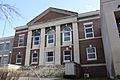
Adams County Courthouse


Images for kids
-

Post office
-
Looking north at the sign for Friendship on WIS13


